Musings

By mid-morning our words for the day clearly had become rain and wind.

However, I did make an outdoor foray with our host that included a stretch in heavy vegetation, like walking through a secret vegetation world, mostly avoiding the wind…

…although mostly we trod blacktop. We found two of these rust-brown newts on one short stretch. Critters!
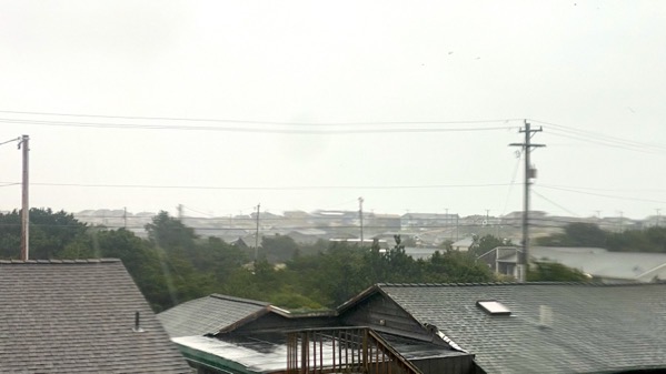
Here’s a late-afternoon view across the neighborhood to the ocean through the rain distorted window.
Posted at 9:59 PM |
Comments Off on All about rain…and wind
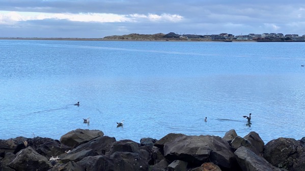
I got up, showered, then strolled down by the bay. I “woke up” these mergies and gulls, or at least my footsteps persuaded them to depart the rocks.
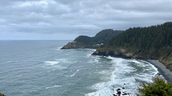
Then we hopped in the car and headed south along the coast. Our first stop was this viewpoint for Heceta Head Lighthouse.

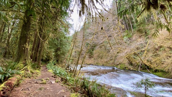
Next stop: the trailhead, and lunch…mmmmm.

The trail followed Sweet Creek, with many spring wildflowers…

…a few catwalk sections…

…many waterfalls…
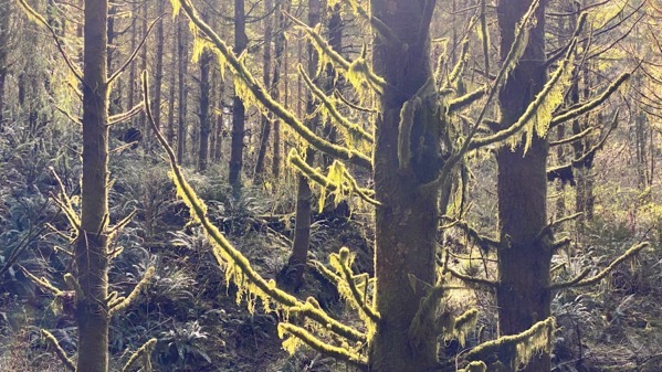
…and looming moss-festooned trees. These are small cousins…

…of the old growth that once reigned here. Note the slot the logger made to insert the board he stood on to cut down the giant.
Posted at 9:50 PM |
Comments Off on Forest walk

We exited the city in fog and continued in fog into the country. Hazelnut tree orchard to the left.

Oh, look what we spotted! Mystery how it got there….

The last snow we drove by en route to the coast.
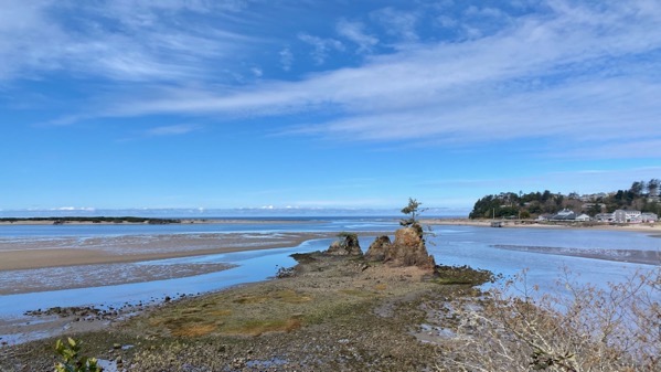
Where we found the tide was out.
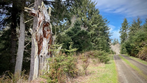
We met up with our friends who took us to a special place with woods roads and trees and even elk droppings and a soaring eagle and an eagle on a nest.
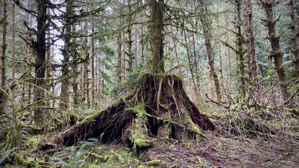
Old growth stump being re-inhabited by the forest.

Forest floor trillium.
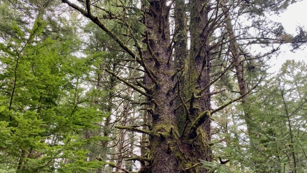
Four trunks on this special tree.

Old Bell System phone for making calls to dearly departed ones.
Fabulous backlighting on the tree-moss.
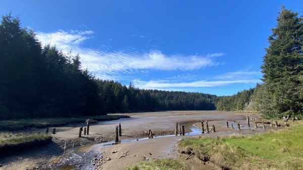
The tide is even farther out…leaving evidence of an ex-bridge.
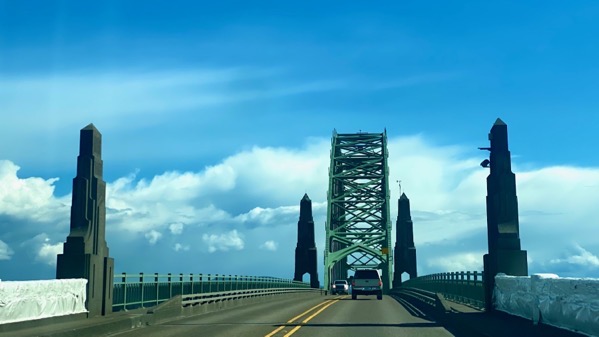
Active bridge.
Posted at 9:14 PM |
Comments Off on Fog to sunshine
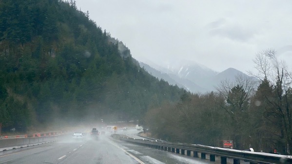
Rainy all day, sometimes more than at other times. And here’s just about the last snow (right of center) we saw from our various vantage points as we went down the gorge to the Rose City.
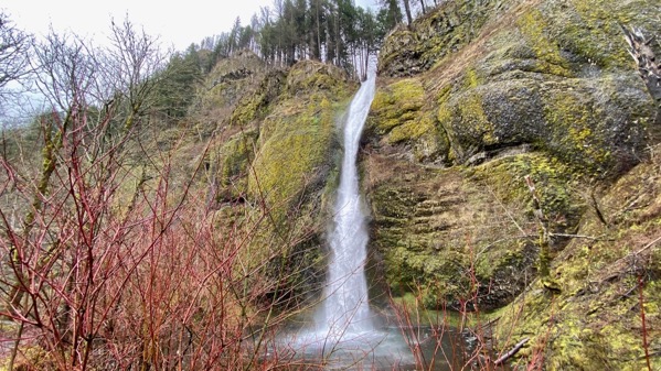
All this rain means…tada! Waterfalls. This is Horsetail Falls.
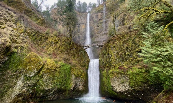
And this is the better known Multnomah Falls. There are pedestrians on the old road bridge…and no longer any cars.

From the natural history display: an osprey. (Photo especially for those who’re tired of landscapes.)

Portland is a city of treasured neon, or at least I have the sense there’s plenty of neon here, and some of seems to be historic…or perhaps just retro.
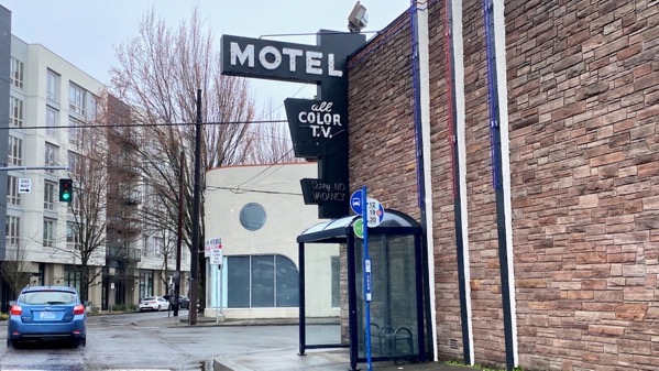
This is not our hotel, and if we didn’t have a reservation, I still don’t think we would have been tempted. See note above. Just to be clear, we have two, count ’em, two color TVs in our room (it’s like a studio apartment, BTW).

Powell’s City of Books: of course we visited. And we traveled via street cars (trams), on complementary tix from our hotel. The Rose City is so green and hip.
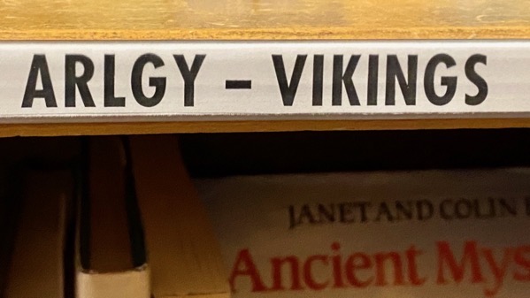
I have never before seen this abbreviation, and I’d rather it disappeared. Only two-thirds of the shelves had it; the rest had the full spelling: archaeology. Much classier. And, besides, there was room for the other letters…so, why? Why?
Posted at 9:53 PM |
Comments Off on Rainy day adventures

We were high enough and north enough getting up in Winnemucca that we had heavy frost on the vehicle. Fortunately, the sun fast-melted it.
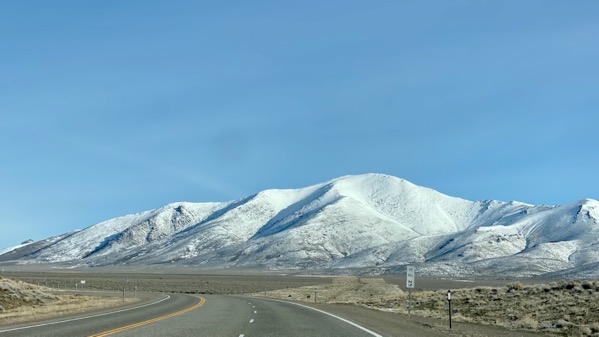
Out of town northbound the road was dry (and it was all day—yay!), although we could see relatively fresh snow above, and sometimes melt-rotted snow nearer the road.
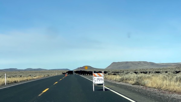
Whoops! What’s this? A hand-made sign: 5mph. Ah, and cattle. I’m calling it transhumance. I think the shepherd was trying to get the cattle to cross the road.
I think the humans were off to the right trying to relocate the herd to a pasture across the road. It didn’t help that the gates were not totally opposite, so they had “sweetened the pot” by putting little piles of alfalfa along the desired route. I think it probably worked well after we were gone.

Driver Spouse eased along and finally parted the herd. Most of them moved back to the right. I stared them down. Oooooh.
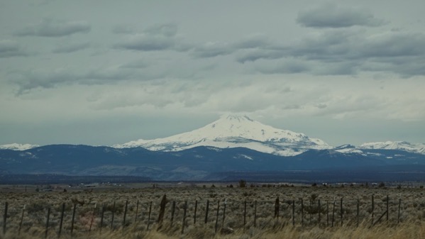
Miles later, the which peak is it game began. We knew the order: the Three Sisters, Mt Hood, then across the Columbia, Mt Adams, and somewhere between Mt St Helens. We weren’t sure we could see that, however.

Note the sign…chain removal area. Yeah, we had to carry chains or have what I think are studded tires in order to pass through some stretches of road today. No one was out there checking, but we didn’t know if they would be, so this morning before we left Winnemucca we became the proud owners of a set of tire chains. They’re expensive! We’re very much hoping we can take them back to a different store, unopened, and get a refund. Fingers crossed.
The kindly (?!) DOT had anticipated the which-peak problem, and installed labeled arrows. Of this pair, Hood is left and Adams is right. You can see a slice of Adams and nothing of Hood at this time/angle.

We continued north and had to loop several hairpin turns down to cross the Deschutes. The Deschutes is a lovely river, and the town of Maupin seems busy, with an active railway and even a grain elevator.

As with the previous photo, note how green the slopes are, now that we’ve descended oh so far.

Crappy moving photo, but, look, there’s the Columbia!

Ah, yes, a darned big river…Lewis and Clark and their fellow travelers passed by here.
And the meta-message of the moment is: we made it north to the Columbia before the storm hit. There will be snow on higher elevations on roads to the coast south of us, not just in California, but also in Oregon. The snow has already started, but many elevations are getting “just” rain. By the time we head to the coast in two days, we should be just fine. Yay. We could have been hosed getting to the coast, but our friends we’re going to see on the coast warned us in time, and we made a bee-line north from Pahrump, staying far enough east of the mountains that we could sneak through. Rain is coming tonight, as well as frozen stuff some places that we came through. That’s why I noted above: we had all dry roads today.
Posted at 11:11 PM |
Comments Off on Transition up down and north

Here’s a cheerful bit of embodied history embellishing the courtyard outside our room this morning.
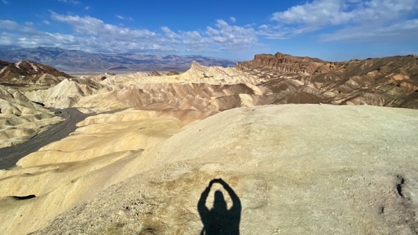
Our first major stop was Zabriskie Point. It’s likely you’ve seen it in fashion shoots or a movie. I was there.
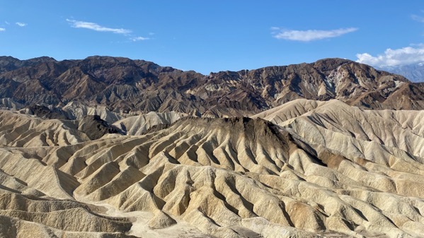
I liked this formation the best. I call it Black Cap.
Art by MotherNachur took a different turn as we proceeded northward in the Great Basin. When a cloud is touching the ground, it means (usually) precipitation. If it’s cold enough, well, you get my drift.

Oh, let me interject a photo of mountains not created by MotherNachur. According to my info, this is from an adjacent big hole in the ground made by a gold-mining company.

Austin Pass on US-50. We were so happy the roads were wet and not snowy or icy. Full speed ahead!

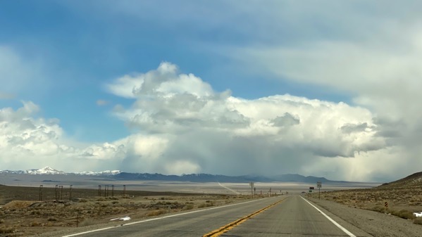
And we were even happier to see snow on the summits far above us, and pleasant temps in the valley where we are now. This has been quite a day for zooming through the Great Basin; it’s endorheic, and has no natural drainage outlets. And it’s huge. And relatively unpeopled.

I’m not sure how to read this in any detail, but those blobs over northern California are what we are avoiding by swinging inland and north, to, ultimately, access the Oregon coast from the north. Those blobs mean heavy precip, and at elevations it means snow, and that area has many relatively high passes on the roads out to the coast. Our Nevada legs have worked perfectly (despite a bit of graupel and a few wet flakes); we hope our luck continues in Oregon.
Posted at 8:47 PM |
2 Comments »
We’re overly weather-aware these days. Another one of those river storm systems is threatening northern Cali, which is where we have been heading toward. Rrrr. So, we’re sensitive to storm-like deposits and have been checking out the snow at higher elevations.
And noting our own altitude.

And seeing that high winds have derailed semis.

Although, we also notice that the arid landscape is greening. The magic of spring….
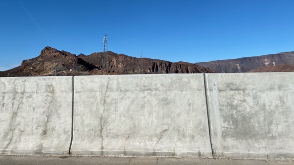
This is the view passengers in low-slung vehicles now have of Hoover Dam. Note that these barriers are higher than the ones in GooStreetView.

Passing west of Vegas, we spotted more snow-capped peaks, and green in the vegetation.
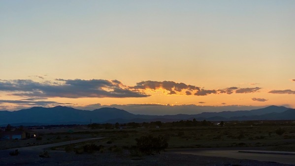
Another stupendous sunset, so very wide and dominant.
Posted at 11:59 PM |
Comments Off on Altitudinal notes

We found a scenic vista view spot in central…well, base of the panhandle of Texas. Afterward, we drove and drove on plateau flattishness.

We didn’t intend to visit the stockyards in Clovis, New Mexico, but all of a sudden we were there. Fortunately, there were no sales today, and no hustle bustle, and no bawling and 💩

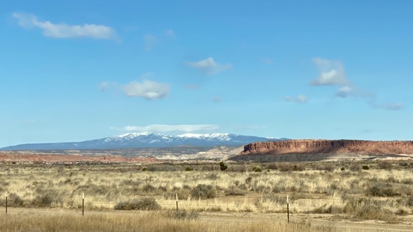
I took this shot out the side window toward the north, after we had left the flat flat flat and were approaching the pass that would take us through to Albuquerque in the Río Grande valley.
This is the snow we could see ahead of us…although this is further along where it was densest. Temps were above freezing, so no worries; the pavement was too warm to become icy.

Stepping out of a Tex-Mex (more or less) family restaurant after we ate, we could see the Sandia Crest (just north of the gap the interstate that we arrived on came through), with snow on the ground and snow clouds above.
The weather reports this evening featured many discussions of locations receiving graupel (we caught some graupel on the windshield at times). Tomorrow should be…interesting.
Posted at 10:33 PM |
Comments Off on Graupel (not a Texas town)
Apologies for the delayed post; I was wiped last night…. Our route yesterday was consistently west from Hot Springs toward Lawton/Fort Sill. We traveled on Interstate, US highways, State higways, and even county roads. There was only one short gravel stretch, with signs saying watch for flooded road; we were lucky as the ditch water was about five feet below the road surface. This is the land of flash flooding.
However, we did avoid the cops in Mena!

This part of the world has many lakes that are reservoirs. For this one, I’m guessing they left the trees telling folks it’d make great fish habitat. Some kind of habitat, anyway.

Disrespect for signs.

We stopped briefly in this small community, so I could stretch my legs. The houses on either side of this street had the barking-est dogs; however, it took almost five minutes for someone to come out and ask what I was doing. This was the view out of the hamlet; I decided not to walk closer to this agricultural implement.

We diverged a bit north to visit the quirky community of Medicine Park. The quirky here is a busy resort/ex-hippy-style place, I assume for a change of pace for those who get off-base from Fort Sill, or away from the fields. We got terrific burgers (this is beef country, after all), and spotted this decoration in a planter.

We crossed the river on this fine bridge leaving Medicine Park. It predates hippy-style.

PDQ we entered wild lands, and saw…tadah! A real wild thing. Two actually, lone males several miles apart. We’re still looking for antelope.

The open plains offer a whole different sunset experience. This dramatic graduation lasted for perhaps an hour. Such a contrast to my experience of the sky in the eastern woodlands.
Posted at 10:22 PM |
1 Comment »

The south-flowing Great River of south-central North America in all its springtime glory. At least it looks like it may be swollen by seasonal runoff.
Posted at 8:11 PM |
Comments Off on Big Muddy