Musings

Autumnal nature tableaus have a vastly different energy from those of spring or summer. I love the fungi in any season (don’t know why), and always wonder what wandered by and took a nip when that evidence is apparent. I once observed a turtle nibbling a mushroom, but this looks like it must have been food for a different sort of critter….
Posted at 2:55 PM |
Comments Off on ’shroom diners

Okay, so today’s sunnier, but I haven’t a landscape photo to do it justice, so here’s a weedy survivor of summer, the Midwestern version of the sticky-seeded plants that scratched our ankles in NM.
Posted at 10:22 PM |
Comments Off on Autumnal weeds

Mid-Michigan this time of year is either brilliant or grey (its own particular, rather depressing shade) and overcast. Guess which today is?
Yes, I’m back (thanks to Delta and the application of a credit card); too much to be sorted out to do from afar.
Posted at 1:34 PM |
1 Comment »

Worth visiting next time you’re in the area….
Posted at 6:12 PM |
Comments Off on Silver City
While southwestern NM is easing into full autumnal splendor (except the dead trees), Atlanta is already there, with lots of color and the first leaves drifting down and changing the lawns from green to golds and yellows.
Posted at 10:22 PM |
Comments Off on Latitude, altitude

Travel day today, which for me meant a connecting flight through the Dallas-Fort Worth airport. The place has several terminals connected, for those already through the security inspection, by an above-ground wheeled monorail (lots of fun!). I enjoyed the architecture framing the waiting area, nothing else to do ’cause I knew I didn’t want to tote the Sunday NYT (paper version), which is large even with the icky sections removed.
Posted at 10:22 PM |
Comments Off on Angular braces
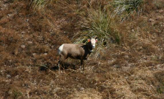
Okay, here’s the scene: we’re driving on the river road upstream from Gila, checking out its condition for next time. Conclusion: just barely passable in the present condition with our wee rental car. Returning to town, and the highway to El Paso (via Silver City and Deming), we saw this guy (?), and a partner. By the time we got stopped and dug out the big camera with the long lens, they were down in the dry arroyo below the road, and I got this shot.
So, what is it? My first impression, when they ran across the road was “goat,” because the horns didn’t curl. Then I checked the web, and I revised: “sheep,” since all the mountain goats look totally different. And when I checked out this high-res photo, I also saw the radio collar. So, is it a bighorn sheep? Or, possibly an imported Barbary sheep? Or?
My final conclusion: bighorn mountain sheep (Ovis canadensis)….
Posted at 10:22 PM |
2 Comments »
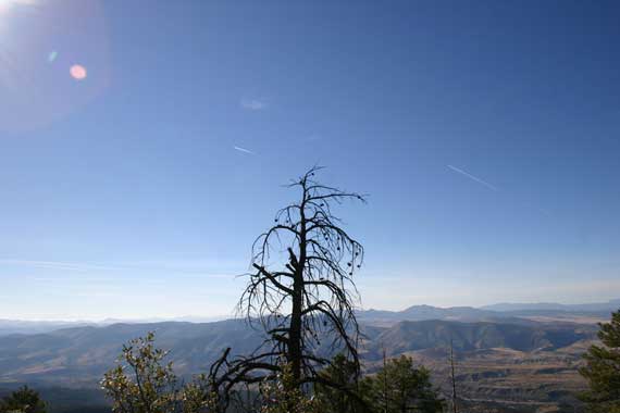
Yes, the sky looked this blue for real. No, I don’t know why (Pooh? Elevation?).
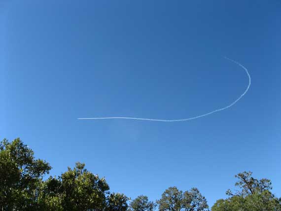
Just when I was getting ready to believe that there might be a no-fly zone over the Wilderness area, I discovered I was wrong. Today we hiked up the west flank of the National Forest that borders the west edge of the Wilderness, and saw this at one point, over the valley to the west of us. The sound reached us well behind the plane as it zoomed by, not surprisingly….
We figure we ascended over 2500′ in 3.7 miles, whew!, then turned around and tried to not skid on round rocks and the like when descending. The trail: Little Whitewater. It wasn’t our original choice, but when the ranger at the Glenwood Ranger Station said he thought it the most strenuous in the area, well, we just had to give it a go. I’m almost still panting from the effort….
Posted at 10:45 PM |
2 Comments »
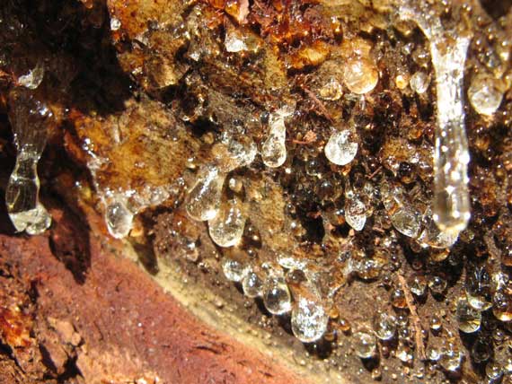
I must include a micro shot: this is pitch from a pine that fell across the trail.
Today’s selection: a trail going either up (first) or down (on return), with virtually no straight and even. Really. You’d think: mountains…well, yes, that’s how it is, elevation change should be the norm. Well, today we experienced it intensely. Over two-thousand feet in 3.75 miles (if you believe the GPS), mostly through beautiful ponderosas and other evergreens, although sometimes the small-plant carpet underneath included healthy stands of poison ivy…. But, we’re tough transplanted Midwesterners, so we persevered, even along steep switchbacks. The most treacherous places were the spots where the oak leaves (and one stray maple’s glowing red leaves) blanketed the path…. Did see one squirrel…where are the thousands of others?
Posted at 8:24 PM |
Comments Off on Elevation change!
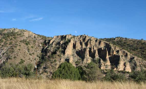
Today’s hike (about 11.5 miles) was a loop that took us through canyons, Little Bear and Middle Fork of the Gila, near the Gila Cliff Dwellings Visitor Center, with only a single ridge to traverse. The main valley near the VC is open, framed on the sides by low rock faces (low if you don’t have to climb them, that is). Some of the flats have various grasses, all a lovely golden, which hides the fact that they’re treacherous this time of the year, inserting their aggressive ,wee, pointy seeds into any passing sock. Coming down the Middle Fork we figure we crossed the river at least thirty times, so I wore my Keen sandals, sockless, thereby thwarting nature’s seed distribution system.
Posted at 9:56 PM |
5 Comments »