Musings
Over 17K steps today (thank you, Fitbit; no Apple Watch yet!), from an expedition to the Caelian Hill. That’s immediately south-southeast of the Colosseum. Look for the cluster of gladiators with Aussie accents checking their smartphones, and head uphill.
We found a quiet park (Celimontana) and a closed park (Celio). I was bummed because the one I really wanted to see was the Celio. Still, in the Celimontana, it was shady and we got to listen to flocks of noisy parrots in the treetops. Yes, in Rome.
We checked out several indoor locations, one museum and two churches. Well, actually the museum included church ruins, so maybe two-and-a-half churches. Rather unlike us….
The churches constitute a study in contrasts. Here are the two active churches.
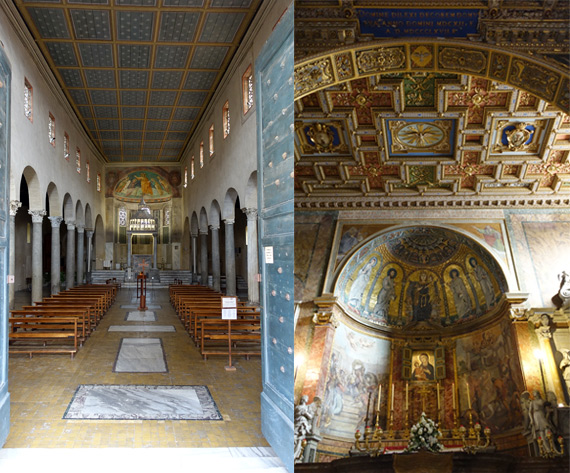
The left one is San Giorgio in Velabro. The name harks back to the ancient Roman name for this area, the Velabrum. For decades, guidebooks have said this was a marsh, as mine does, but recent coring across the neighborhood indicates that it never was a marsh or a tributary of the Tiber or a boat basin (among the comments you may read/hear). The church dates back to the 9th C, and I love that the grey granite? columns run out toward the rear on the right, and different columns are substituted (only one in photo); indeed this part of the floor is also higher, suggesting it was an earlier structure incorporated into the church. The entry around the doors had to be rebuilt after a Mafia bombing (why here?) in 1993 caused considerable damage. The rest of the church was restored in the 20th C. The ceiling is obviously a substitute. The painting over the altar is simple, yet brilliantly colored. Since we didn’t plan on visiting this church, I only discovered later that we could have peeked into a niche and seen the skull of St. George, who is famous for dragon-killing.
The church on the right is Santa Maria Nova. The city is overrun with Marian churches (honoring Mother Mary), with very few names mentioning Jesus. He dominates altar-paintings, of course….
This church is on top of a small rise that must have been taller before the valley gathered sediment (8–10 METERS in the Forum area, more that happened after abandonment, and has been removed to reveal the ruins we see today) and perhaps it was borrowed a bit. The ancient Romans named all hills, valleys, and parts of hills around their city, as well as neighborhoods. This low hill in the valley was the Velia. The only access is from the Colosseum along an old section of Roman road, and indeed we walked uphill.
An earlier Santa Maria church in the Forum was relocated here in the mid-800s, making this the new St. Mary’s. The Madonna and Child painting with the shutters that to me is the visual focal point of the apse, is of the Glykophilousa type, a “sweet love” image of the duo, with the Madonna embracing the Christ child, and the child stroking the mother’s face. It dates to the 6th C. I found the bright colors on the ceiling dramatic, set off by a maize of white-and-gold borders. Again, without the guidebook, we didn’t know to look behind grills in the south wall at paving stones described as being from the Via Sacra (road into the Forum from the east), and bearing the imprint of the knees of St. Peter, praying for the punishment of Simon Magnus, who was flying about. We also didn’t know to check out the crypt, including a Bernini.
Serendipity only floats you along so far.
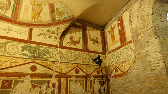
We toured the Case Romane museum, which is a maze of ruins beneath the Basilica Santi Giovanni e Paolo al Celio. It is named for two brothers, martyred under the last non-Christian Roman Emperor, Julian, in 362. I have studied the map of the rooms we walked through, and it just felt like strange little spaces, with doorways leading from one to another. I was further discombobulated because the floor and ceiling elevations were up and down, and at most three rooms in a row had floors on the same level, and perhaps that consistency was introduced to make them accessible parts of the museum. Some ruins date to ancient Roman times, but part were the rooms of early Christians, late 3rd C, and into the 4th C. As near as I can tell that’s a goat and a camel near the corner, hanging from a rope to the torso, and with no hind legs. Haven’t a clue what this imagery meant to the occupants of this space.
Other activities today: we walked the length of the Circus Maximus (gigantic), and looked at archaeology in action at the SE end (the turn); I even saw a trowel! We saw cats at the Largo Torre Argentina (everyone does; they live there). We noticed little lizards in the park. We saw napping men on benches in the Piazza San Marco (noticed in other parks, too). We enjoyed the decrepit nature of the fenced-off Arch of Janus, which is really not an arch per se, but a squarish four-arched triumphal monument—only now its only triumph is that it still stands.
Posted at 3:44 PM |
1 Comment »
Yes, everything is plumb; the wide lens has “bent” the towers, light posts, etc.
We checked out the Trevi Fountain and the Spanish Steps, with the boat-fountain in the piazza at the foot of the stairway. Serendipity brought us “broken” fountains—covered in scaffolding or otherwise waterless and walled-off, allowing workmen access, but not tourists*.
C’est la vie.
We detoured up onto the hill above the Steps and worked our way north stopping for a meal at a place that had turtles in a pool in the middle of the dining room. Interesting choice. We did not find out the story behind the turtles. Their skin had broad black and yellow stripes (the long way on their legs, necks), and they had humpy backs almost like painted turtles, but no color pattern, or not much of one, on their backs. Dark brown or near-black.
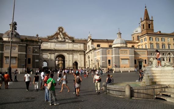
We descended into the Piazza del Popolo, moving from shade-spot to shade-spot (temp about 90°F and HUMID). It is just inside the city gate on the main ancient road entering Rome from the north. As near as I can tell, Rome’s strategic location was also a transportation hub, and this would have been the approximate route of the path along the river, heading inland on the south bank, judging by the topography.
This broad space was opened up in the 1530s to impress visitors entering the city. The center has an ancient Egyptian obelisk set above a fountain with four lions with water pouring out of their mouths. More choices intended to impress.
For us, the broad plaza was more of a blistering, sun-filled obstacle, and we walked purposefully along the shortest route between shade and shade. We passed two guys setting up for a variation on the impossible man/stick/Indian-swami pose (they covered themselves in a piece of fabric, keeping the secret of levitation obscured—I’m betting it’s a metal framework attached to a fellow’s torso and under his arm; there are several variants on the levitation pose, some with one guy, some with two). We continued past the fountain. We got into the shade on the other side. Whew!
We turned around to gaze back at the space—only half is in this photo. Look, JCB said, there’re motorcycle cops with lights flashing. They were near the city gate, which is for pedestrians only. We kept watching. There were also cop cars here and there around the square, and one that crossed through it. No lights strobing on them, though. Hmm.
Pretty soon, down the switchback route we’d descended came a small group of runners. As they looped around the fountain we could see there were twenty at the most and the front guy had two flanking guys and was carrying a torch, or what looked like a torch (long metal thing).
Behind the runners was an open jeep, large size, with a few guys in camo, and two with special hats that looked like they were covered in crow feathers. I’m sure I got that wrong, though. Behind that was a closed military-looking Red Cross vehicle, I think four people crammed on the bench seat in front. The remaining police car fell in behind them as they passed us, and off they went headed down the Via del Corso, right toward the civic-ceremonial center of ancient Rome.
Couldn’t tell what their affiliation was, no banners…. More serendipity!
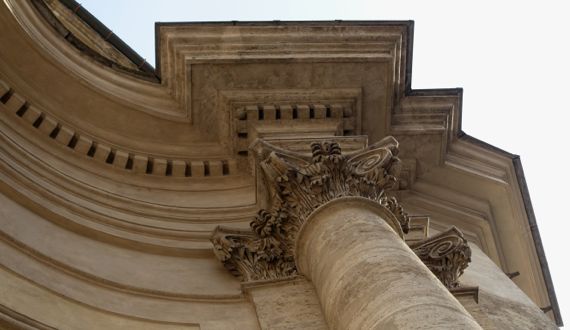
For some architectural eye-candy close up and because I love these details, this is from one of the churches on the south side of the Piazza (tada! Corinithian).
* The city had kindly set up a small pool at the Trevi for people to throw coins in, but I wonder if the substitute pool has the same power as the legendary fountain to bring coin-tossers back to Rome.
Posted at 5:03 PM |
Comments Off on Serendipity kicked in
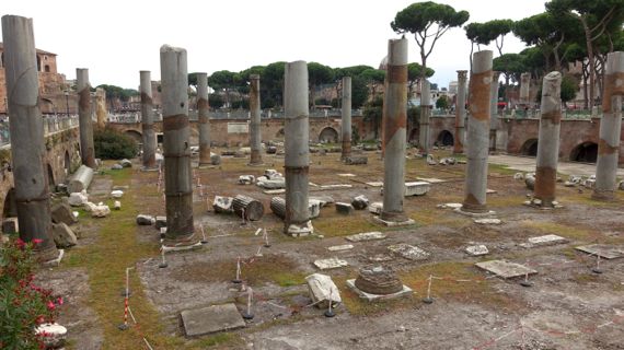
The ruins of the Basilica Ulpia (north part) are framed by these two rows of columns. The footprint outlined by the columns continues to the right out of the photo and under the road.
The Basilica Ulpia was part of the Forum of Trajan, much of which is now covered by roads and buildings. Basilica at that time meant a large building with a public court function; Romans usually sited them adjacent to a town’s forum, the locus of commerce and governmental activity. Typically, basilicas had interior colonnades that allowed the building to be larger, and visually suggested a series of linear areas. This is the pattern adopted by early Christian temple-builders, and still used today. The earliest basilicas date to the 2nd C BC, although this one dates to the early 2nd C AD, or at least three centuries later.
Ulpia sounds pretty strange, and unconnected to Trajan unless you know that the Emperor Trajan’s (b. AD 53; d. AD 117) youthful name was Marcus Ulpius Traianus like his father, our word Trajan being a corruption. Ulpia is the gens (family with a common ancestor) that Trajan and his father identified with. Their ancestors were Roman colonists who settled in Iberia in the 3rd C BC.
The most striking surviving art from the Forum of Trajan is a triumphal column just to the far right outside this photo. It has a spiraling bas relief panel that portrays Trajan’s victory over the Dacians, who may have included my ancestors. Trajan’s Column is hollow, with an interior spiral stair, an engineering wonder that allowed access to the top, over 38 m above the ground surface. Despite earthquakes over the years and modern traffic and vibrations, the column remains almost exactly vertical.
The inscription on the square base is famous for what it says and for its letter forms. It says that the monument is in recognition of Trajan’s long service. The letters of the inscription are viewed as fine examples of Roman square capitals, and several modern typeface designers have used them for inspiration, including Carol Twombly, who designed the oft-used Trajan typeface for Adobe.
Displayed next to the column is an “unrolled” photograph of the bas relief, along with some commentary.
And all this eye candy is free!
Posted at 2:32 PM |
2 Comments »
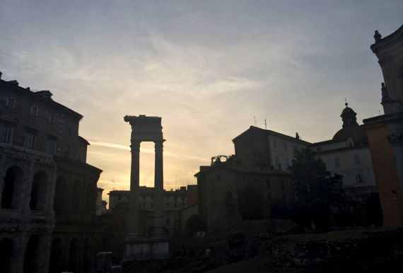
That’s the Theater of Marcellus* off to the left, with ruin fragments scattered about this area, framed by later buildings to the right, still in use.
As to wifi, we’re on the TIM team (both words pronounced the same)—with an Italian SIM in our hotspot, so we have data even when walking around (until the battery discharges). Anyway, kudos to the Guru for making technology serve us….
We hear a lot about how much cheaper phone and data packages are in Europe vs the USA, but it seems to me that they pay considerably more for devices and peripherals. SIM card was something like 15€ (that’s high)…, and, geeze, the unlocked phone prices, whew.
* Julius Caesar set aside space for the building and construction began, then he died, and it was five years before the building was formally dedicated, by Augustus. Like other monumental architecture in this city, it was repurposed as a fortress in the Middle Ages. Now apartments are jammed in the upper stories, with the lower sections being…ruins stabilized sufficiently to be foundations. We only walked around the back of the theater this evening; we’ll see what the other side looks like another time.
Posted at 2:27 PM |
Comments Off on Old, newer, and new
World’s largest unreinforced concrete dome, invisible, to the left….
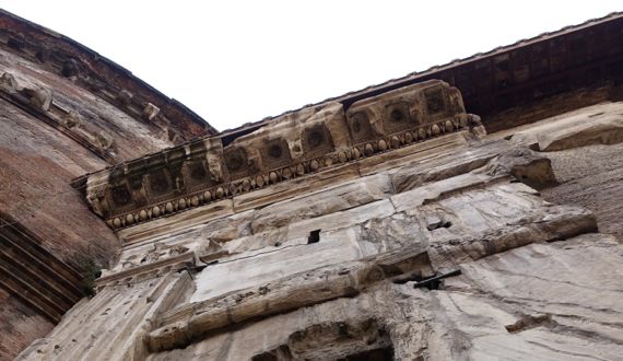
We looked at two round buildings today. We got to enter the Pantheon, along with several hundred folks in tour groups, small groups, and couples. Wow! Whatta space! Loved the shapes built into the surfaces, all the gaudy treatment down low and pure architectural simplicity up high. Oculus was spell-binding, along with its huge light-dot.
I suppose I am rather rude here by just showing you the close-up of how the rectangular porch attaches to the famous round central room, and the remaining bits of exterior horizontal architectural detail.
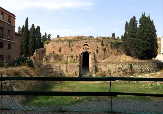
We didn’t get in this one, the Mausoleum of Augustus. Like pretty much every bit of architecture from the ancient days that’s survived in this city, it has been robbed of building stone and decorative elements, and rebuilt and repurposed. This one is amidst another revival phase, which looks like it’s been stalled for several years judging by how robust the grass and weeds are, although it was charged with being finished this year. Ah, yes, Italy’s current financial crisis?
The lower level we see now, that was street level when this was finished in 28 BC. Augustus did not die until AD 14 (making the current architectural revitalization timed with 2K yrs after his death), and several decades before that Strabo described it as a great mound. See, it had a checkered history before the guy it was built for even died! Much of what we see is the 12th–C remodeling into a fortress by the Colonna family. In the 20th C it was for a time a concert hall, including hosting Arturo Toscanini leading a concert here.
The Pantheon (hall of all gods) was commissioned during the reign of Augustus, in 27 BC. Recently examined bricks, however, indicate that construction of this version dates to Trajan’s time (he ruled 98–117). Two intermediate versions burned (hence the Trajan replacement), although the building has remained in use since it was built. The whole north porch has been re-conceived and rebuilt several times, including that the porch extended several meters farther north, and the open garden that was to the north is long gone. The piazza there looks like its surface has been raised by several meters, as is typical across the old city.
Posted at 10:56 AM |
Comments Off on Round building musing

Oh, that Gitche Gumee is formidable, and continues to maul this wreck. Water levels higher than I’ve seen for some years, I’m pretty sure. We read 57° and 59° as we drove along the shore, with a wind that made it…chilly. But the brilliant sun compensated….
Posted at 10:16 PM |
1 Comment »
Did a wee (and I mean wee) bit of thinking about the power of the Internet in connecting people who otherwise would not encounter one another. Not ground-breaking, that thought, but worth contemplating for several reasons. I was considering how/whether it makes for a significantly different dynamic when considering how civilizations and societies function.
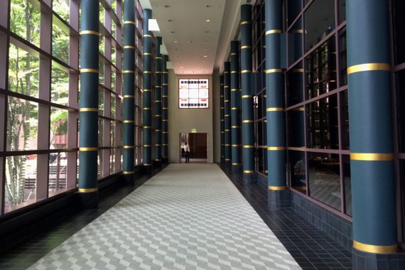
Meanwhile, back on Planet Earth, is this broad, empty hallway in a busy well-populated office building this size mostly to satisfy fire regulations? That’s a lot of square footage that can never be rented….
Posted at 7:44 PM |
Comments Off on Connections
I’m back to slogging through the details of Rome’s architectural history (mostly before about AD 400). I find that I have to parse the details first and get them close to “right,” then I try to step back and see…patterns. This afternoon it finally hit me that two ancient shrines were adjacent—shrines to water and fire. The legends place both in very ancient times, so they probably pre-date Rome-ness in some form.
The water shrine (and pool) is the Lacus Juturnae, and the fire-shrine is the Aedes Vestae (usually termed temple in English, blurring the difference between shrine and temple to the Romans). An everyday nymph honored by the first, Vestal Virgins tending the second….
The ancient histories record that there was a sacred grove around the Temple of Vesta, so the Lacus, only a few meters away, must also have been in the grove…. To me they seem like they were paired, at least symbolically, in early times. As Rome grew, the importance of the Lacus must have waned, based on its small footprint and reduced ease of access—plus the insertion of a ramp between the two (attributed to Emperor Domitian, b.51–d.96; it connected the Imperial palace atop the Palatine with the Forum).
Anyway, when I finally put this all together, the fire-water neighborhood seemed especially important, culturally loaded, and… ignored in the literature that I’ve peeked at…so I’m probably just taking meaning when there was none. Ah, can’t be the first time that’s happened (sarcasm). 🙂
Posted at 10:22 PM |
Comments Off on Archaeos and patterns, again

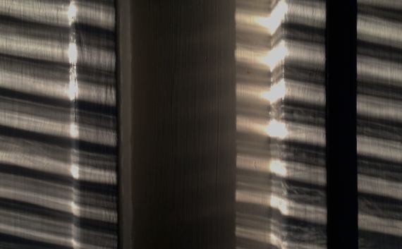
I like the lighting very much, but what I notice most is the mold seam to the left.
Posted at 10:13 PM |
Comments Off on Yes: flash
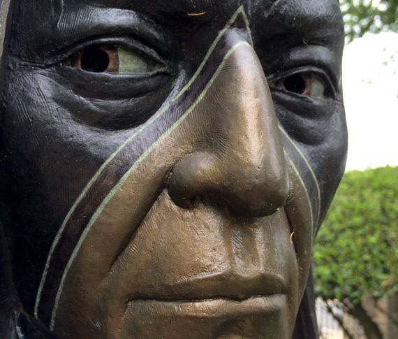
Love outdoor statuary you can walk right up to. Thank you, Booth Museum.
Posted at 6:44 PM |
Comments Off on Friendly or fighter?