Musings
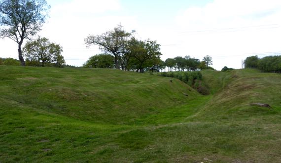
This may be the last about Roman occupation on this trip. This is a turf fort on the Antonine Wall, called Rough Castle. The Romans took twelve years to build this wall, and after eight more years they abandoned it (the forces of political economy…). To the right is the land of the barbarians, with a ditch and rampart in the mid-ground, facing the threats…to the far left is the fort, and I am standing on a gate (I assume; one sign on the whole fort…). This is the second-smallest fort along this wall, and the best preserved. It’s rough, humpy ground surrounded by a ditch, and would be a royal pain to sketch-map with a compass by pacing.
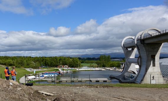
By the time we got to the other side of the hill (roughly speaking), the sun was out, and we found two guys and a drone watching the Falkirk Wheel. This is some major industrial engineering to bring boats up/down between two canals at very different heights. The drone is left of center near the top and the boat is at the bottom ready to enter the lower basin. The arm takes the boat and water on side, with a counterbalance on the other. This lift replaces eleven (I think) locks that used to be used to span the 79–foot elevation change.
As we climbed, we saw many plantations, including bits of Tay Forest. Some of Tay Forest is old(er) growth…. And rivers, some with rocky beds and rushing water. Elevation….
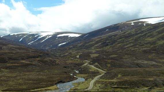
As we climbed higher, we got above the treeline (or at least where trees have not returned since the last glaciation), into glacier-rounded peaks and valleys, with some snowpack remaining. The dark brown landcover is heather. The lambs up here are much younger than at lower/warmer elevations, and most were hunkered down napping, not gamboling about, as we have seen everywhere else.
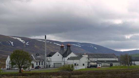
We have driven past several whisky distilleries, but have yet to stop. Crazy, eh?
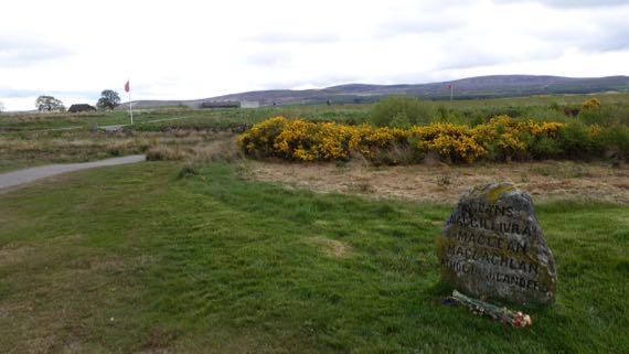
Many men died on this relatively flat moor, properly called Drumossie Muir/Moor, including Scotsmen fighting on both sides. This is where the Blàr Chùil Lodair, or Battle of Culloden, happened beginning about one in the afternoon of 16 April 1746. The Jacobites, who sought to restore their beloved Stewarts to the throne, opened with cannon fire, and English forces answered with their own cannon. As the National Trust for Scotland puts it:
Bombarded by cannon shot and mortar bombs, the Jacobite clans held back, waiting for the order to attack. At last they moved forwards, through hail, smoke, murderous gunfire and grapeshot. Around eighty paces from their enemy they started to fire their muskets and charged. Some fought ferociously. Others never reached their goal. The government troops had finally worked out bayonet tactics to challenge the dreaded Highland charge and broadsword. The Jacobites lost momentum, wavered, then fled.
Hardly an hour had passed between the first shots and the final flight of the Prince’s army. Although a short battle by European standards, it was an exceptionally bloody one.
Culloden was the last pitched battle on the British mainland, and the ramifications for the Scottish people have been immense. The English subsequently sought to suppress ethnic Scottish behaviors, including kilt-wearing, the Scottish Gaelic language, and the clan social structure. The effect of these changes was a depopulation of hinterlands, and disruption of pretty much everything Highland.
This and other rough stone markers were installed in the 19th-C. Archaeologists have used non-destructive, remote sensing techniques to define the areas where bodies were buried in mass graves.
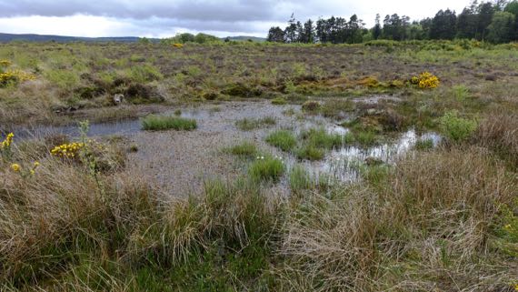
Another problem for the Jacobite troops was that the part of the battlefield they sought to cross was even wetter than today, slowing the advance of a major portion of the line. Indeed, this was a little marsh we found that would have been difficult to slog through.
Managers of the battlefield are encouraging the plant species that were here on the day of the battle, and the moor is turning from pasture into…gorse and grasses, along with wildflowers and other woody plants. One type of feature that was here in 1746, but is mostly gone now, are stone field enclosures…. The powers-that-be are also trying to convince landowners in the preservation area to refrain from tree plantations.
Such are the cycles of land management.
Posted at 4:22 PM |
Comments Off on From violence-bracing to violence
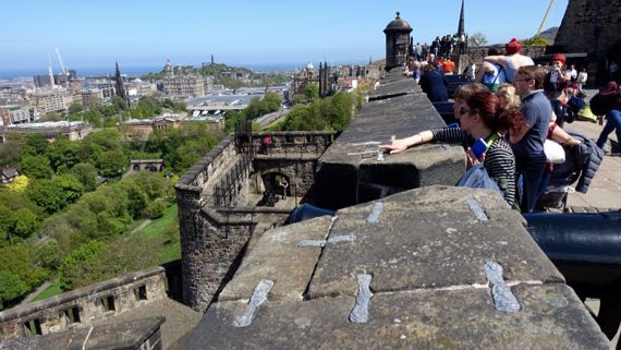
The preferred castle location: defensible, lofty, fortress position. From this massive castle hill, Edinburgh is laid out below, with occupation stretching to the Firth of Forth, where the River Forth melds with an arm of the North Sea. I loved this parapet, and the views.
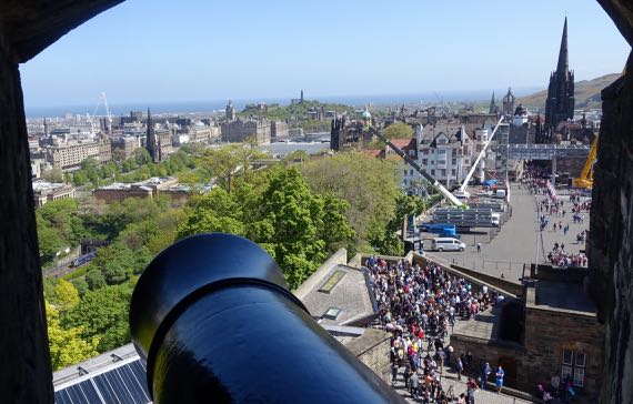
Of course, the cannons also have a great view. BTW, that mass of people to the right of the barrel and far below, sweating in the sun…that’s the line to buy tickets. It’s a holiday weekend…plus for a while, three of the six windows were closed. Sheeesh.
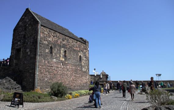
You can see a bit of the volcanic whatever that makes this feature extend far above the surrounding landscape. All the cannonballs and castle-terraforming have not eradicated or covered it. This building is the oldest one standing up here, a chapel dedicated to St. Margaret of Scotland (~1045–1093). It was built by her son, David I, previously mentioned in this space…. One of the fine things Margaret did was establish a ferry across the Firth of Forth. [Now there’s both a railroad and a road bridge.]
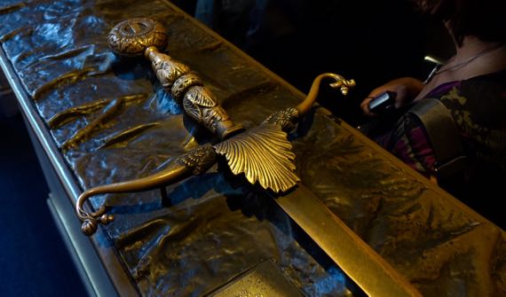
The most moving exhibit for me was our visit to the stronghold within the castle, where the Honours of Scotland are kept. These are the most symbolic objects in the nation. No photos/film allowed, so outside are bronze…not-quite-replicas. This is the claymore/sword (replica), which has a 4.5 foot blade. The real one is a bit more battered, and a bit sharper. Also in the room with the Honours is the Stone of Scone (I’ve seen pronunciation suggestions both as “soon” and to rhyme with done; haven’t heard anyone say it). I wanted to be more excited about this stone, for its history, but I couldn’t get there. The Stone has been used in coronations for something like eight centuries, customarily stored in the chair in which the sovereign sits when the coronation happens. It has a checkered history, and many doubt that this is the original. No matter; it remains very meaningful today. It was in England for recent centuries, and used in coronations there, and finally returned to Scotland in 1996. It’s not pretty, just rough, pitted sandstone, and suffers in comparison to the shiny and glittering sword, scepter, and crown in the same display.
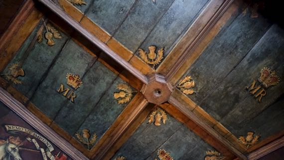
This is the ceiling of the bedchamber of Mary, Queen of Scots. It’s a small room, with nice wood paneling. And a window. And paintings on the walls just below the ceiling. I have no idea what furniture was in this room; there’s just a chair now.
I kept trying to visualize the pre-Scottish fort that was here, and the earlier castle-layout(s). This castle is still in active use, for official activities, for rental, and of course for tourism. Outside the gate, they’re installing a huge seating gallery, using giant cranes to lift large steel I-beams into position. I didn’t catch what it’s for….

Posted at 6:36 PM |
Comments Off on Super-castle!
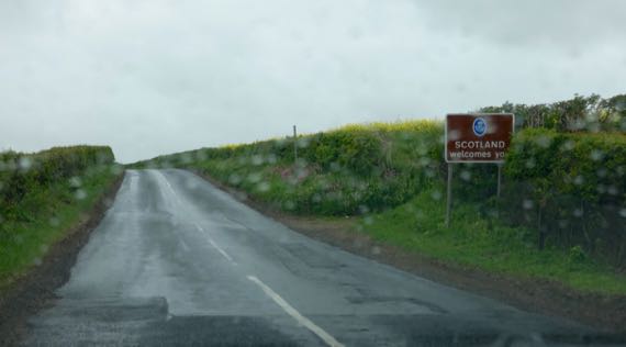
Today was designated Abbey Day in our itinerary. It was not wrong. What we really did that was most important was get to…Scotland! (And, yes, mostly we had a rainy day.)
Historically, as today, there’s a sociopolitical core to the north and south on this great island, and somewhere on the lands between has been a border zone. Today, the border’s an agreed-upon line across the landscape. For generations, it was a wide swath of contention. The border was generally porous, often dangerous, and yet had economic potential in an agrarian economy. And, land, after all, is land, and land is territory.
From the 1100s–1400s, a castle on this hill, between two rivers, was a political and economic center. Kings lived here, and both the northern and southern sides held it in repeated succession cycles. This was Roxburgh Castle, founded in the mid-1100s by David I, King of the Scots from 1124 until his death in 1153. Now, at the foot of this rough double-hill, there’s a small layby with room for maybe four vehicles, and no signage.
King Henry I (coronated 1100, died 1135; fourth son of William the Conqueror, King of Normandy) held sway in England, but suffered from pressures brought by rulers on the continent, in Normandy and elsewhere on the northern rim.
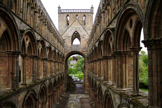
The economic and political elite of the time included both nobility and the guys who controlled large abbeys-and-churches. They were two sides of the leadership coin. Yet, the petty kingdoms of the time rarely could dominate the peripheries for long. Accordingly, cagey religious leaders were happy to build and run Jedburgh (above) and several other abbeys not far from the Roxburgh core that for centuries held sway in the borderlands—and to feed off and accept the wealth of the nobility as donations to fund repeated monk-prayers (see how well it worked, the buildings of…almost…all are now in ruins). The leadership of some of these abbeys came from afar, others from Lindisfarne….
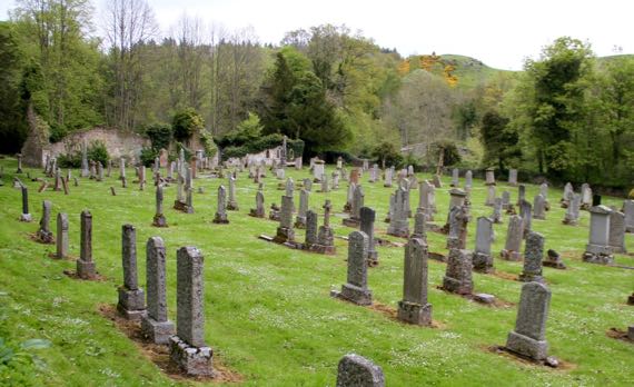
Into this general pattern of upheaval over the centuries, the place I found most interesting that we visited relates to my family history…. Traced through my mother’s father’s mother’s ancestors, we get back, after something like a dozen generations, to the Livingstons of Ancrum, post-Reformation (them, post-Dissolution) men of god here. The original Christian outpost here was established by David I, and it became a parish church after the Reformation in 1560. John Livingston became the minister here in 1648. Some of his relations migrated to the New World in the later 1600s, including signer of the Declaration of Independence for New York Philip Livingston (1716–1778). Anyway, (somewhat tenuous) family ties to the village of Ancrum (pop. ~300). In older times, the town center was west of the modern town center, near the ruined church, now surrounded by (mostly) 19th- and 20th-C headstones, and across the river from the ruins of a flax mill….
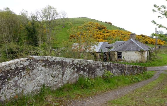
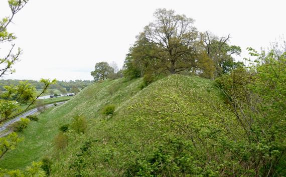
The icing on the cake…across that bridge by the church-cemetery, and up on the hill that has yellow blooms on the woody shrubs, are the remains of an Iron Age ring fort!
Posted at 10:22 PM |
Comments Off on From kings to peasants, via local leaders

This is a rhododendron, although the individual blooms in the clusters look a lot like azalea blooms. Apparently, the anther count varies.
Posted at 9:50 PM |
Comments Off on Bumble rumble
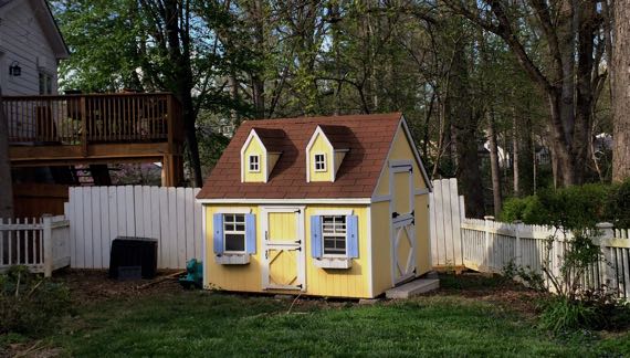
I walked past the neighbors’ house, and it was a pile of rubble. I think it was felled this morning. I knew this was coming….
Instead of giving you a photo of the slightly depressing hill of random building material, I present this sweet little pastel playhouse.
Posted at 8:52 PM |
Comments Off on Architectural transitions
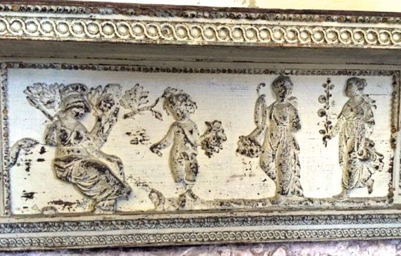
Drayton Hall, c. 1750 (but for over a century believed to date a decade earlier), mantel detail.
We visited the American version of the English version of Classical Greek/Roman decorative arts. Not sure what mythical moment this is honoring, maybe…let’s look at flowers because it’s really cold out…thankfully sunny, but still cold.
A little chemistry and political economy…. In the depression that followed the Civil…umhem, War between the States, an economic downturn that lasted for about six decades in the Charleston (SC) area, savvy landholders benefitted from mining calcium phosphate along the Ashley River and nearby (upstream of Charleston). The calcium phosphate was processed to make particularly rich agricultural fertilizer. By the 1880s, the phosphate from this field dominated world production. But it didn’t last long…new fields discovered in Florida were easier to mine, and there were other market shifts.
Enough of this…sleep tight.
Posted at 9:32 PM |
1 Comment »
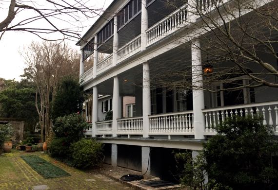
This “side porch” is officially a two-story piazza here in Charleston SC.
Posted at 6:38 PM |
Comments Off on For better breeze-catching
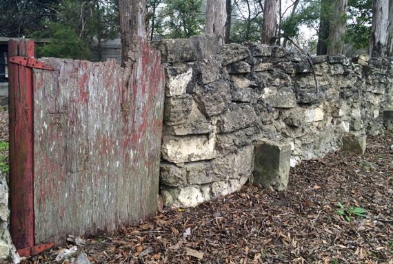
I really liked that the post for the right side of this gate was a turned newel post, painted the same red, and also flaking grey. I also liked the construction method for this wall, with different techniques used for various sections. The part had large stones and little mortar. To the left, the wall was sloppy with drooping layers of fairly fine-grained concrete and smaller, flatter stones. All portions had about the same amount of floral encrustations.
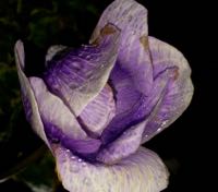
We found this flower, an anemone, elsewhere…after dark.
Posted at 9:30 PM |
Comments Off on Hinged gate in a stone wall
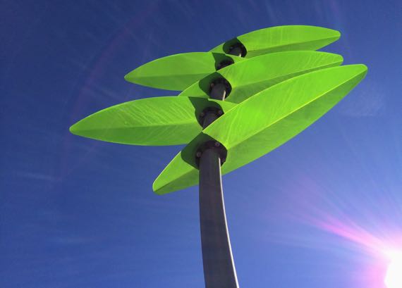
Such a gorgeous warm and sunny day…we are so lucky! This “palm” “waves” over the water area (not turned on yet) of the playground in the upper H4WP.
BeltLine report: PACKed.
Posted at 10:22 PM |
Comments Off on Out, about
Neighborhood decoration…(only one shown).
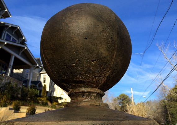
Isn’t this the homeowner dream? A pair of giant concrete finials on posts flanking their driveway?
Posted at 4:50 PM |
Comments Off on Livin’ the dream