Musings

I look at this carpet and think, “I have no idea how to decode this textile,” or: once again—my ignorance. This piece was made, I’m pretty sure, before 1950, and perhaps a generation or two before. It’s some kind of special, perhaps not very. I wonder, however, as I tromp across it wearing outdoor shoes.
Posted at 10:17 PM |
Comments Off on Patterns of the past

This was yesterday morning’s prediction of wind chill for the day. None of the stations did weather this morning. I could understand except for the scary-cold aspect of conditions. I know it was worse just about everywhere north of us, but, geeze, all that stuff about public service…kinda out the window today.
Posted at 8:21 PM |
Comments Off on Holiday hiatus
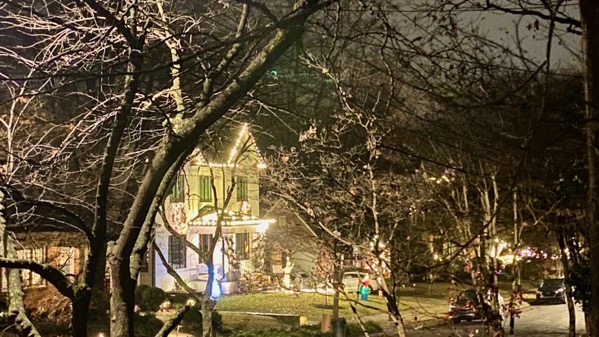
Light show. Does it put you in the holiday spirit? Me? Not so much.
Posted at 9:49 PM |
Comments Off on Light times

Just watched RWarnock on Reidout. The interview was at a pre-Covid favorite hangout of ours, the Democratic stronghold Manuel’s Tavern*. Joy knows how to say it—like instruction manual. No kidding. Don’t know why, but that’s the way it is.
So, the berries in the left package were priced at a premium, yet I couldn’t tell much difference between the sizes of the berries. In truth, I don’t think the left packages was worth one-third more….
Election Day tomorrow. Hoping for truth there, too.
* Stronghold as in JFK, Bill Clinton, Barack Obama, and similar, along with uncounted state and local officials and candidates.
Posted at 8:05 PM |
Comments Off on Truth
Watching the high early-voting counts and hoping…that some of the inaction in Washington is blocked. Don’t understand how people re-elect people to represent them who so frequently act against their personal best wishes.
In other news, a conviction on seditious conspiracy for not-going-to-include-his-name on his 6Jan behavior. Three days of deliberation. Those jurors get extra points.
Posted at 7:28 PM |
Comments Off on Views

We did our civic duty, and stood in line to early-vote. Along with many neighbors. Not all regular voting locations are open, and voters can go to any open location. This is a calculated strategy to make it more difficult to early-vote by bunching up those who elect to early vote. This strategy was crafted by anti-civic A_holes elected by not-me.
Despite the difficulties, I understand that early voting numbers are very high. Yay!
Our location is easy to get to from the city’s business district, and it is often shown on the news, including national and international stories.
We ended up discovering that we had a common friend with the fellow in line behind us…voting is a way to meet a neighbor, it turns out. After all, we were in line for 110 minutes until we cast our ballot.
Posted at 7:10 PM |
Comments Off on We voted

We continue binging on “Yellowstone,” a series that is a five-star lesson in corruption and how the wealthy bend the world to their selfish desires. Here: the lady governor and John Dutton; Dutton is set up in Season 4 (where we have reached) to run to succeed her.
BTW, this version is pinker than any Montana we have ever seen. And, the ranch they use for the filming for the Dutton home is indeed in Montana, although many other locations are in Utah. TMI?
Posted at 10:02 PM |
Comments Off on Location, location, location
I spend some intellectual energy now and then on “political economy.” With whatever sense of a lens I have from that, I think DT is running again because it’s the best business model he’s happened upon in the last decade, the model most likely to line his own pockets and pick up his personal expenses. Sure, there’s an ego component, but IMHO it’s about money. Money. And money.
Posted at 9:13 PM |
Comments Off on The baseline
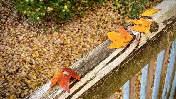
I did not pose those leaves. MaNachur’s fine aim that gently deposited leaves on that railing. Gravity is powerful. Aesthetically guided gravity is even more impressive.
Also, I finished “West with Giraffes” (by Lynda Rutledge, 2021) today, a LOL read, and that is not commonly a comment of mine. Recommended.
Posted at 8:40 PM |
Comments Off on Finesse

I don’t hear about voters on the fence, which seemed like a standard phrase back about a generation. This fence has no voters.
Posted at 8:36 PM |
Comments Off on Grindstone in background