Musings

We began the morning in a fog. Real fog. We took care of the coffee-fog with the usual medicinal application!
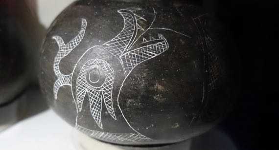
At our first stop, we went back in time to the Mississippian world, which must have been rich in symbolic imagery, stories of other-worlds, and so on—enough to make you shiver. Archaeologists and art historians call this critter the horned serpent, and also use uktena, which is/is from a Cherokee word.

Next stop was in Selma, the Edmund Pettus Bridge. We didn’t walk across, only part way; however, we drove across three times We also looped by the Brown Chapel AME Church, which is where the SCLC met, and where the three marches in 1965 that headed from Selma to Montgomery began.
Posted at 10:08 PM |
Comments Off on Considerations
For a time, tall, blocky, stone tower-houses were the rage in Ireland. Perhaps 2K survive today, and thousands more are rubble or gone. Since they took considerable labor, they must have been valued.
I read an article about them today, describing murder-holes and machicolations, which are design details that were all about defense. The author also described a battering-ram test his squad(?) did, which took minutes to take down the door. His conclusion was that tower-houses looked far more defensive than they actually were.
I think they were about elevation—about keeping a lookout. And perhaps visual communication (flags? smoke?) among the many towers, as they were often built close enough to see one from another.
Posted at 10:22 PM |
Comments Off on Of murder-holes and machicolations
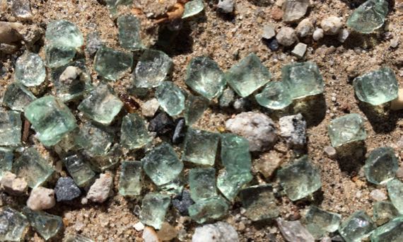
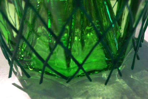
Turns out that this kind of safety glass is, terminologically, really toughened glass, which I know as tempered glass. Sounds like the toughening process resembles the quenching/tempering of metal.
Following a WikiPee rabbit hole I discovered lead me to Prince Rupert’s Drops. Strange thing: drip droplets of molten glass into cold water; recover when cool. They will have an elongated teardrop shape. Try to crush the bulb; it will be hugely resistant. Snap, break, or crush the skinny tail, and the whole thing will fragment into dust. So I have read. Apparently the tail and the outside of the drop cool faster than the inside, which stays molten a bit longer, yielding a tensile stress pattern that makes the tail weak and the bulb strong. Or something like that.
Anyway, I think this is auto window-glass, fragmented into cuboidal shards.
My other research adventure today had to do with the royal sites of Ireland…medieval period…there are four of them. Five. Six. Depends on the definition.
Wait. One more research adventure: KW taught me what a zarf is. I told JCB, and he said nooooooo…then looked it up. From a Turkish term, he says.
I am now more learn ed, that is learned pronounced with two syllables.
Posted at 11:07 PM |
Comments Off on Research adventure(s)
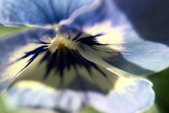
I’m being barraged by Henry VIII of England. First Wolf Hall. Tonight it’s Lucy Worsley’s version….
Yeah, I know Henry’s symbol was the rose not the pansy. My wee joke. Plus, pansies are blooming now and roses aren’t.
Posted at 11:47 PM |
Comments Off on Haunted maybe?
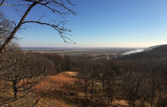
We headed down by the river, the Missouri—that seems like it should be the Mississippi to me when you look at the size of the catchment…. That’s it off to the right. Look at that broad floodplain past the channel….
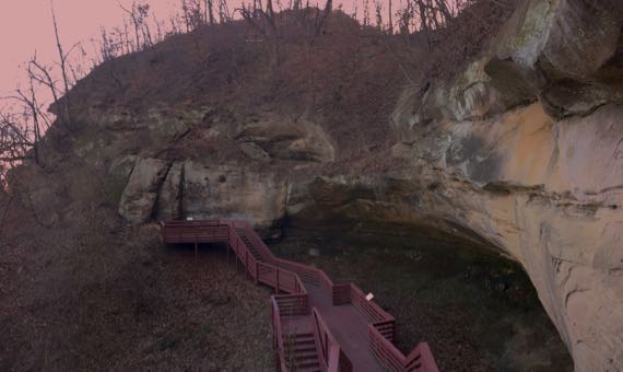
And next to the river, in an unusual bluff, a cave—or a kinda-cave—carved by nature in soft stone, perfect for carving by humans, too. The few petroglyphs the native peoples left are eclipsed by dozens of carvings added in the recent past—including this summer, I daresay. [Apologies for the grotty color; I tried to correct it, no luck—not my specialty.]
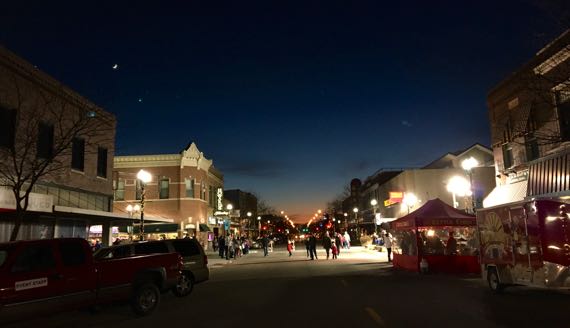
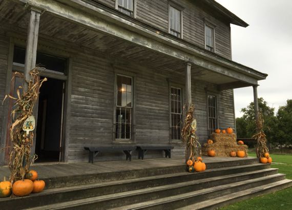
We wound up in Grand Island’s downtown (the real, old downtown, and not the highway strips and mall area), where everyone was gearing up for Main Street Xmas (or something like that). Love the fingernail-moon witnessing.
Posted at 7:34 PM |
1 Comment »
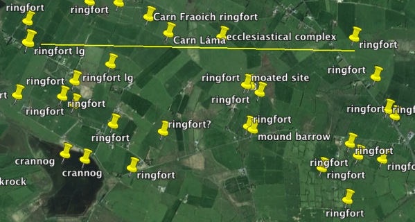
Look at that ringfort density! That line is 2 miles long. These people were pretty close neighbors (dispersed homesteads); you could go next door for a cuppa…something, not sugar or coffee. Some of the greater distances are across creeks/marshier areas. Crannogs are artificial islands—very defensible housing locales. See how small many fields are today?…a legacy of thousands of years of chopping up control of the landscape.
Posted at 10:22 PM |
2 Comments »
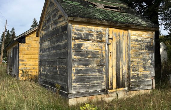
These are two outbuildings in Blaney Park. This alley is mostly ghost town, but some of the buildings on the main road remain in use. Blakey was quite the resort in its day, with a landing strip and swimming lake, golf course and dance hall. Now, the dance hall is mostly closed, almost no one swims in the lake, and the others are…archaeological.
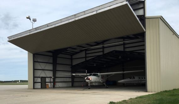
Then I went industrial, and saw this hanger, larger than its denizens.
We ended the day at a loverly restaurant, all very yummy—beet salad! whitefish salad!—and more…. Even better was the company, of course.
Posted at 9:58 PM |
1 Comment »
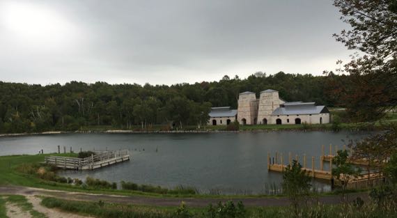
We gambled with the weather and headed out to Fayette, an industrial ghost town. These two furnaces (rebuilt, I’m pretty sure) produced over 230K tons of charcoal-iron over 23 years, ending in 1890. This mean the surrounding area was dotted with charcoal kilns to provided fuel for the furnaces (over 80 within 10 miles). In a generation, the forests were gone and so was the operation.
This was the town’s hotel, later called Shelton House. Most of the rooms are on the second floor and the back of the structure has a two-story outhouse, so that roomers did not have to descend or use a chamber pot.
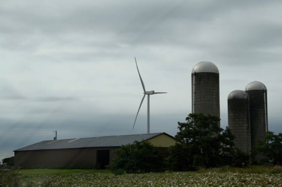
A new industry has come to the Garden Peninsula, just a few miles north of the ghost town—we counted about fifteen wind turbines, all generating on this windy day.
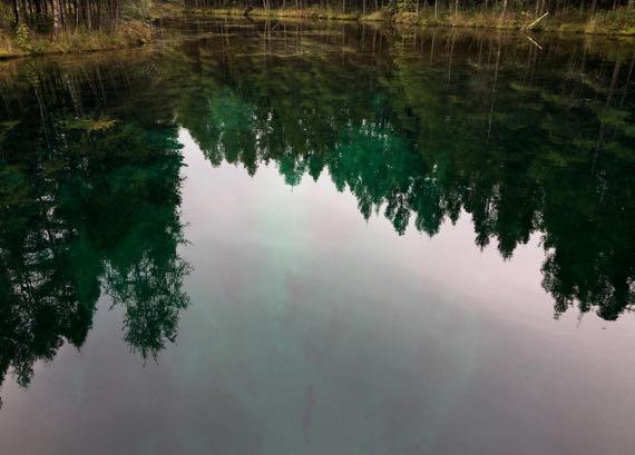
We detoured to the Big Spring on the way back, aka Kitch-iti-kipi. No fishing allowed so there are giant trout. One is that vertical black line at the bottom center of the photo.
Posted at 6:58 PM |
Comments Off on Blustery day
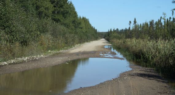
We crossed this long flat stretch, marred by puddles crossing the road, knowing that the dribbles and currents they carried were waters of the Tahquamenon that evaded the culverts. We drove north, and it almost looks like it’s swamp all the way to Lake Superior; however, if you look closely, you can see the ground does ridge to the north. The swamp will end after maybe a dozen more big puddles.
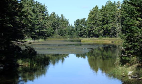
Eagle’s Nest has changed a little over the years—and almost not at all, simultaneously. The bridge and cabins, yes, they come and go and are modified. The river—this is the Tahquamenon again—looks very much the same as in my oldest memories of this place.
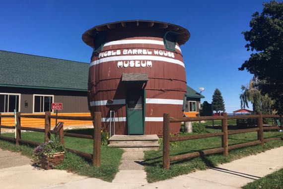
On up in Grand Marais (perhaps a corruption of maré, meaning sea, and transformed into marais, meaning swamp—which there isn’t here on Lake Superior’s shore, at least not a huge one), we once again beheld the Pickle Barrel House (on the National Register, BTW). This was a two-story home with a kitchen in an extension behind, built for Chicago cartoonist William Donahey, who drew The Teenie Weenies. He and his wife used it for a decade at its original location on Sable Lake, then it was moved to town.
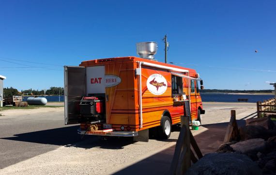
Of all things to find in Grand Marais, a food truck! With “burgers” and “taco’s,” I kid you not.
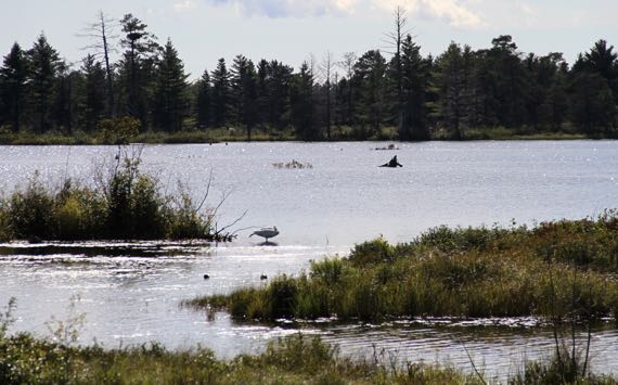
Turning homeward, we looped through the wildlife drive at the Refuge, and found this swan sleeping on one foot. We saw many swans feeding, often with a few ducks? (grebes? coots?) futzing around them. The latter didn’t seem to also be feeding, and we couldn’t figure out what the advantage was of hanging with the swans, close enough to sometimes annoy them.
Posted at 6:54 PM |
Comments Off on To the north
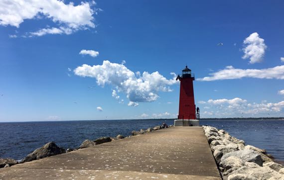
Square steel lighthouse…built in 1915, automated in 1968 (if I remember correctly). Seagulls love it.
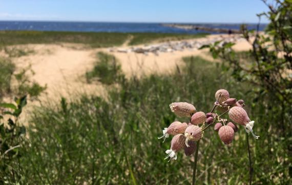
And on the dunes on the way back, we saw these bladder campion blooms, incongruous on their skinny stems.
Posted at 11:08 PM |
Comments Off on Mouth of the Manistique