Musings

Should you wish to drive from Michigan’s Upper Peninsula to Florida, here are general directions. First, cross the Big Bridge. Poufy clouds today….

Then, head south. You’re looking for a sign that reads: State Line…however many miles. Good. Go through Okolona; this is the top of the silos of the huge grain elevators. Okolona is surrounded by maize and soybean fields, with a few patches of woodland, so they can keep a mill very busy during harvest season. Now, head south and look for the Maumee River; it’s substantial, so you won’t miss it. Presto: Florida is where the bridge is. Really.
Posted at 9:18 PM |
Comments Off on It’s simple
I went down a deep rabbit hole for most of the afternoon in locating Pottery Neolithic archaeological sites on the southern Sinai peninsula. Archaeological sites can be notoriously difficult to locate (or not), so that’s not surprising…in general. Fieldwork on several of the sites was decades ago, then repeatedly mentioned in later articles and comparative reports, so you’d think the locations would be…not so mysterious. Not.
In the process of this “digging” (forgive me), I came across Saint Catherine’s Monastery. Before the monastery and Saint Catherine, this is where, some say, Moses saw the/a burning bush. Of course, digging deeper, there are several proposed locations for the Moses/burning bush event.
Now, the Catherine is Catherine of Alexandria, who had the misfortune to be born before Romans accepted Christianity but in their territory, and, not surprisingly, she was tortured for her faith. She died about AD 30, or so the story goes. Although she seems to have remained in the Alexandria area (western Nile delta), somehow the Sinai location perhaps 600 km to the SE had Saint Catherine relics, as, they say, her body was found in a nearby cave. Wow; lots to swallow there.
Look how much I learned without ever finding the exact location of Ujrat el-Mehed (the PN site), although I did figure out the general area. Heh. And in the process found (on GooEarth) the ruins of Gebel Abbas Basha, dating to, as I recall, the late 1700s.
See: rabbit hole. Or, perhaps more truthfully, a whole darned burrow complex.
Posted at 10:10 PM |
Comments Off on All about scale
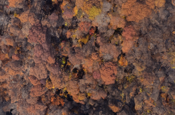
Against the odds, I came across this autumn “broccoli forest”…in WashDC. There can’t have been a long time window for this satellite pass.
Posted at 10:22 PM |
Comments Off on Autumnal
I awakened early the other morning and thought, gee, it’s darker than in summer at this wee hour. Then I thought, ah, the season is turning. And we have arrived in autumn.
These are distortions to tree-cover in the 3D presentation of satellite photos by GooMaps. Makes the trees look like distorted broccoli. [No cookbook.]
Posted at 10:22 PM |
Comments Off on Broccoli forest
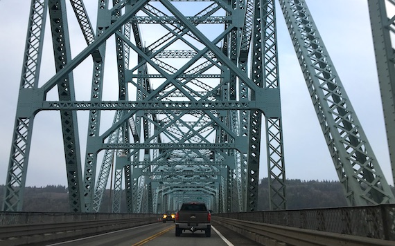
Photo taken last December.
This bridge crosses the mighty Columbia at Longview, and is the second bridge upstream, at 66 miles from the mouth. Its drainage basin is about the size of France, so you know there’s a serious flow.
At some point today I was thinking about rivers and borders. Even small creeks can be borders, I guess in part because in pre-satellite days, most anyone could tell which bank of the river they were on. If that makes sense.
Of course, for its lower miles, the Columbia is designated the border between the USA states of Washington and Oregon.
Posted at 3:42 PM |
1 Comment »

I think I’ve put this mural-sign up before, but here’s this year’s version of viney-signey.
As to Rome-research, I found this fantastic map (Flash) by Katherine Wentworth Rinne showing change over time in springs, creeks/drainage, and aqueducts in central Rome (the Italian one, not the one up the way).
Posted at 10:22 PM |
Comments Off on Time and time

My sweetie and I walked to Emory…and back (cool but lovely weather for this afternoon outing). During my investigations at the library, I discovered that undergrads who are paying an estimated $56K/yr (full freight) must be willing to put up with incompetence at the information (not Reference!) desk. Well, fifty percent incompetence. The second person I spoke with led me straight to the volume I was looking for (in the Atlas Collection—so forward, an Atlas Collection).
Posted at 8:04 PM |
Comments Off on An Atlas Collection?

Over on the west coast of Italy, closing in the northern arm of the Bay of Naples, are two islands. The one farther from the coast, but still not far out, is Ischia.
Off the northeast coast of Ischia is a remarkable island, now connected to Ischia by a causeway. The island’s about 200 m across, and quite tall. It’s topped by a castle, no surprise there (what a lovely and strategic place for a fortification!). Of course, the castle complex, in this Catholic land, includes several chapels. The island hosts thirteen churches.
I was quite tickled to see the shadow this little island casts on Google Maps’ satellite photo.
WikiPee says some scenes in the disturbing movie The Talented Mr. Ripley were shot here….
Posted at 7:09 PM |
Comments Off on Say isss-key-ah

Nothing heavy on this Satt-ah-dee night, but here’s a castle I found while perusing the landscape in Google Earth. I love that you can see the terracing below the lower castle wall. Note the defensive shape of the main wall. As always, where are the storage rooms for food, water, ammunition? That’s the problem with holing up; you need supplies….
Posted at 5:59 PM |
Comments Off on Skinny terraces, and more

We took a different route through Ohio, avoiding the Toledo area by striking across the farmland of the northwestern part of the state. One problem is where to cross the mighty Maumee. This time, we crossed this bridge in Napoleon. At dusk.
Posted at 10:22 PM |
1 Comment »