Musings
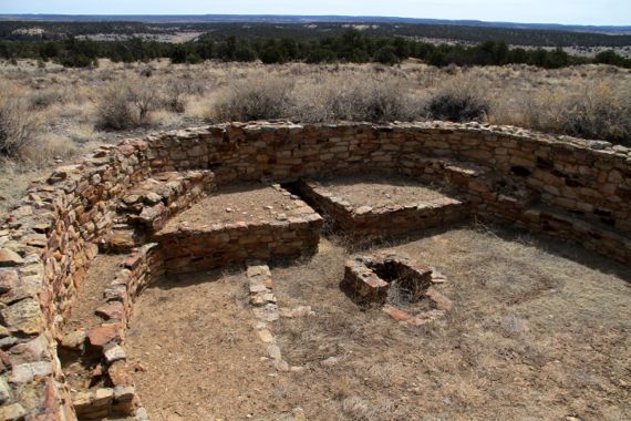
We explored history in assorted ways when we did the walking tour at El Morro, which is a sandstone formation known for its carved inscriptions that began with ancient native peoples and hosts additions well into the twentieth century. Coolest stop: the kiva in the small excavated area of the Atsinna pueblo ruin atop the landform. Maybe a dozen rooms are on view, but reports say there are something like 875 rooms. That’s a lot of construction! It’s dated to something like AD 1300….
Posted at 9:25 PM |
Comments Off on Readable past
I was too tied up and boring today to even walk, let alone create a fresh/fun foto for this space.
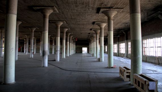
Instead, I give you an interior view of the Sears, Roebuck building we toured the other Tuesday.
This is a view to the west, and the windows look north onto Ponce. The floor is original. Workers had to remove six layers* of carpeting, we were told, to reveal similar maple strip flooring on a lower “shopping” level.
The pillars are original and the floor above is poured concrete. Boards were used to hold the wet concrete, then removed, leaving the stripes you see in the ceiling.
To ensure that the dust created by construction doesn’t wreck the now-exposed wood floors, the developer bought a wood-floor zamboni, and the floors are cleaned frequently.
* Can you imagine the amount of trapped yuck in that much carpeting? Ick.
Posted at 10:22 PM |
Comments Off on Interior stratigraphy
View WSW from Beltline bridge over North Avenue (33.77110,-84.36391).
No reason WikiPee doesn’t have this right, so this nightclub used to be an excelsior mill. I had only a nebulous idea what excelsior is, and finally looked it up. Wood wool. Little fine curls of timber. So, it was a factory for reducing trees to fluff.
Strange what repurposing can make (historical) bedfellows….
Note how the strange weather “cut off” the tops of the downtown buildings—this was soon after the rain stopped….
Posted at 10:22 PM |
Comments Off on More de-manufacturing along the BeltLine
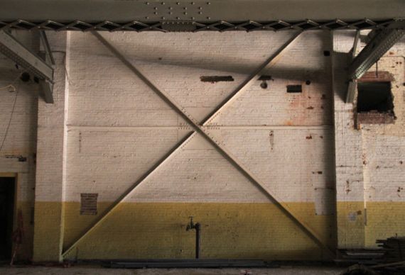
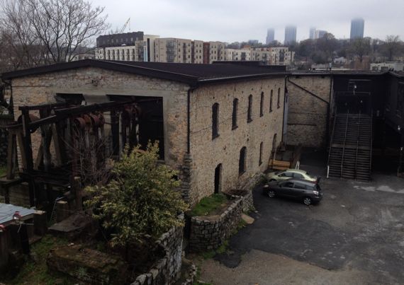
The Fates intervened in our neighbors’ lives, and they offered us the opportunity to tour, in their stead, Ponce City Market, the former City Hall East, the former Sears, Roebuck, and I don’t know what else. The building is something like 2 million square feet, with 56K panes of glass. This is an interior wall, I think dating to the 1920s, the original building phase. Interestingly, this building, adjacent to the railroad bed that’s now the BeltLine, which hosted a spur that went into the building, is built atop springs. That are still producing. Some goes into storm sewers; some is used as grey water. Anyway, fascinating tour….
BTW, the developer, Jamestown, did Chelsea Market and bunches of others; they seemed to know what they were doing at all scales, mega to user to neighborhood to environmental….
Posted at 10:22 PM |
1 Comment »
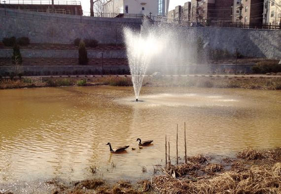
Can you see the two goslings between Mama and Papa?
I’m guessing this is the goose family I saw in the making the other day…. I found the next empty except for some fluff being dispersed by the wind.
Sorry to send more goose-poopers out into the world; on the other hand, it’s a victory for Mother Nature to produce something from what had been for decades a yucky industrial site.
Posted at 10:22 PM |
Comments Off on Next chapter?
Despite predictions of freezing rain, I walked the park, and even saw maybe 30 seconds total of sunshine, in two reveals—enough sun to make shadows. Heartening.
Posted at 9:32 PM |
2 Comments »
I’ve been wandering lately (aka procrastination)—via satellite views on GoogleMaps. I found the Costa Concordia on its side next to the Isola del Giglio….

And I found a grey-face? Maybe? Is this an intentional distortion? An artifact of shadows?
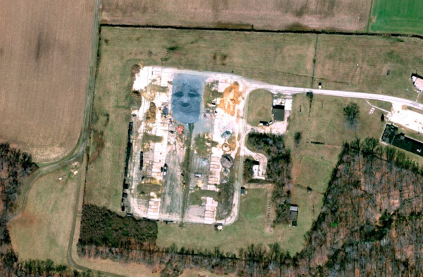
This is on a partly destroyed cold war missile installation inland on Maryland’s Eastern Shore, called Tolchester. Still find the face mystifying.
Posted at 7:23 PM |
4 Comments »
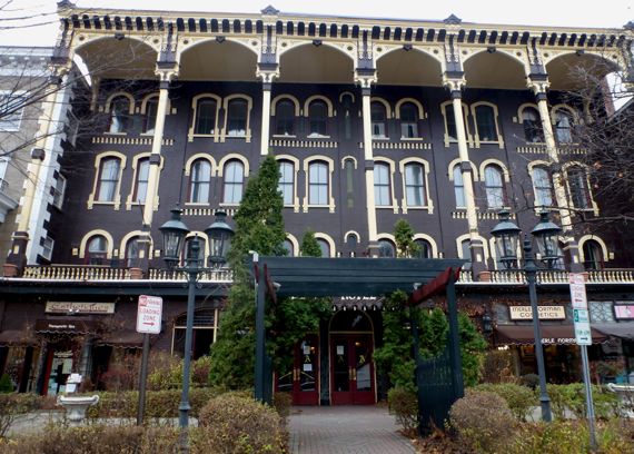
Saratoga Springs. Yes. New York. (Can’t find web domain; like I note, soooo last century.)
Ah, so last century. In a good way.
Here at lunch time. Ate not here at the yuppie place, but down the street at a diner, serving breakfast all day.
Posted at 10:22 PM |
Comments Off on Graaaahnd hotel (not MacIsland)
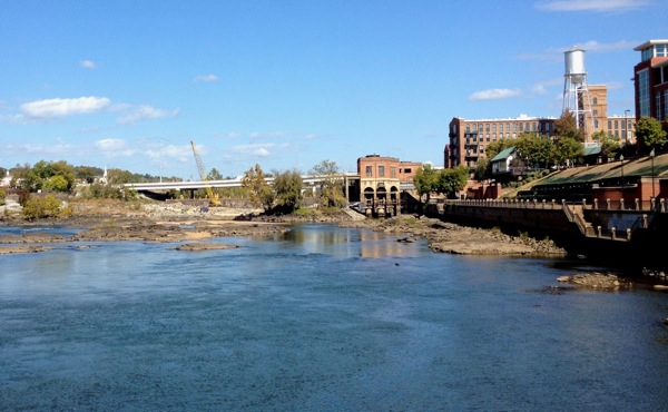
The Indian name for this place, I swear, must have been something like “Rapids with herons and turtles downstream.”
Indeed, the post-Colonials who dammed this stretch must have been channeling (ahem) ancient times, when they named their flow-stopper Eagle & Phenix Dam (two majestic birds of reality and myth).
Of course, when they blew the dam, archaeologists…monitored…what was revealed….
And now, six months after the dynamite (or whatever they used), we saw many turtles, including one with a shell more than a foot long, and herons, including one that nabbed and swallowed a feesh right in front of us, just downstream of the old dam site (or dam old site).
Posted at 9:33 PM |
1 Comment »
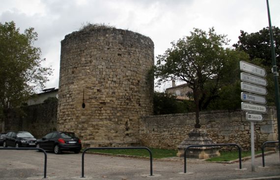
Sometimes when you’re traveling (or amidst life), you have to let serendipity prevail. We made a side loop to visit…Cadillac. Because it was there.
And discovered it’s a walled town, with some plain but impressive ramparts (if, indeed, that’s what they are).
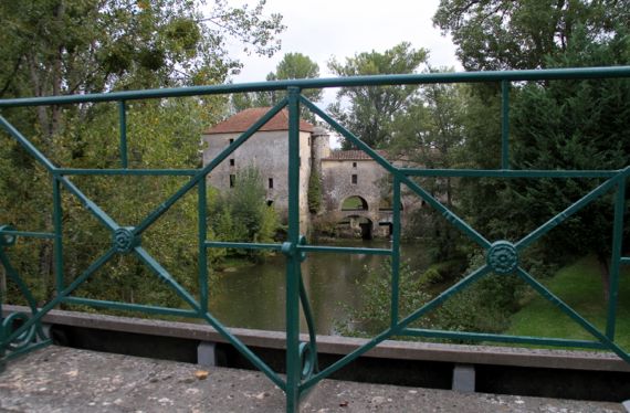
Then we took another side loop to check out a cultural feature signposted as “Pont Eiffel.” There was no pullout nearby, and no way to see the lacy metal support structure of the small (like three car-lengths) bridge in any detail, and we can only guess that the tour-Eiffel engineer had a hand in this one instead of merely influencing it. So, no bridge pix—only this one of the mill just upstream (no public access). Moral of this story: serendipity is sometimes just for your eyeballs—and imagination—and not for your camera.
Sometime later, we passed through an area where the grape-harvest was well underway. The trucks from the fields apparently back up to the gate appropriate to the variety they are carrying. The smell of souring grape-juice and the busy insects were the most dramatic impressions/activity at the moment we encountered this cooperative.
We covered some territory today, and the agricultural crops and general landscape went through several noticeable changes as we left the coast and moved through inland zones. We are overnighting in Perigord, and it is nut/fruit country—no grain and olives are long behind us, as are the chateaux of Bordeaux.
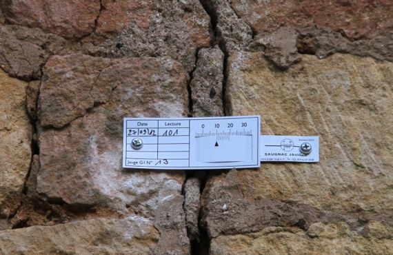
We’re staying in a really small town—the only biz is our B&B—with several homes and a church getting major attention from historic preservationists. The cracks in the walls are being monitored as restoration continues, using these simple calibrated slips.
Posted at 10:22 PM |
Comments Off on The changes we are seeing
