Musings
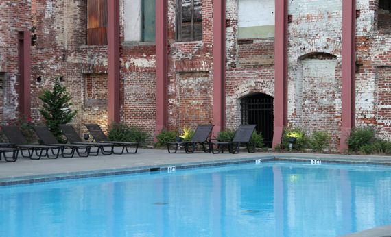
Right in the middle of the former Fulton Bag and Cotton Mills, the developers dropped in an outdoor natatorium—an amenity for residents of the factory-turned-housing complex of today. The weather has turned cool enough that at dusk on this Saturday night not a soul was swimming or socializing poolside.
Posted at 8:22 PM |
Comments Off on Repurposed buildings
Google is amazing. Or, really, what’s out there on the web is amazing.
Recently, a friend suggested taking a look at Hellhound on His Trail by Hampton Sides. So, I requested same of the county library. The wheels of transference brought it to my branch, and wah-lah, I paged through it a bit this morning.
A weird fact jumped out at me: James Earl Ray worked in the bakery in prison, in the Missouri State Pen.
Way back in the mists of time, I worked in Burwell NE, in the very interesting Sandhills (called the “the largest and most intricate wetland ecosystem in the United States” in WikiPee), and one of our local friends was Buck the Baker. You see, one of the stories Buck told, and I never had a reason to doubt the truth of his stories…he said he baked for Uncle Sam during WWII, and one of the guys who worked under him was…James Earl Ray.
What, I wondered, happened to Buck the Baker? He had heart problems when we knew him, and he was well into his sixties, so I figured I knew what I’d discover, but the bigger mystery that had to be solved first was: what was Buck’s “real” name? Several years ago when JCB and I were out wandering, we went through Burwell, and I think I identified the storefront that had been his bakery. It is neither a bakery or restaurant now, as it was then.
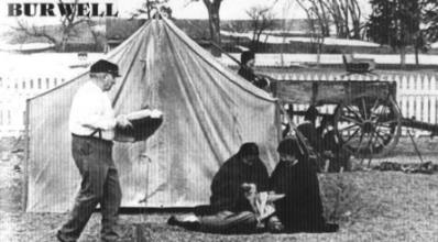
My very first search attempt turned up this Virtual Nebraska page authored by Emma Bristol (thanks Ms. Bristol!), which reveals that Buck’s name was Orval D. Newbury. And there’s a picture!
How heartwarming to find a picture of Buck at Fort Hartsuff, where he loved to bake and participate in reenactments! (That’s him on the left. Here’s a snow-falling-on-cedars moment when we stopped by there.) Buck once served our whole crew “elk* stew”—he said it in quotation marks and wouldn’t answer questions about it) at a special evening event hosted by the manager (I can’t remember his name), his wife (they also had an octagon house down in Ord—I think this one), and their lovely children. How special!
The fall we were there Buck made me the largest b-day cake I’ve ever had, a giant sheet cake. We even sent pieces home with passersby!
Just to close the circle, Google also reveals that Buck went to the great teepee in the sky in the early 1980’s (records I found differ), not long after our fieldwork ended. And, in concert with his interest in history, Buck also left an interview with the Veterans History Project.
* I’m pretty sure the “elk” went moo.
Posted at 11:40 AM |
Comments Off on Cool guy, Buck the Baker
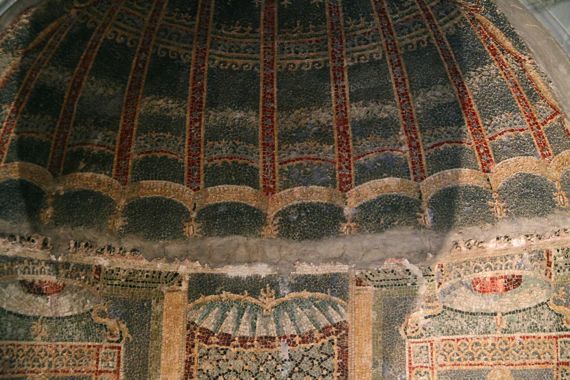
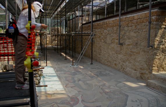
The original—well, the original tiles reconstructed in the museum. With positively lousy lighting.
Today was Museo Archeologico Nazionale di Napoli day. We dodged persistent raindrops getting there from a nearby train station, and discovered the museum was more of a ramble through the art objects from several Naples-area archaeological sites—especially Pompeii and Herculaneum—than a comprehensive survey.
In particular, the museum highlighted that while we have visited those sites and seen roads, sidewalks, walls, and floors, many of the decorations we’ve seen have been copies, while the originals were removed to this institution for safe-keeping—beginning in the 1700s. Well, plus some of the architecture has been reconstructed (rather than merely stablized), too.

The colorful copy we saw at Herculaneum. In somewhat better light.
Both of us were very glad that we saw P and H, the sites, first, and then the out-of-context artwork plopped together sometimes in a mix-and-match fashion that we found extremely disconcerting. One room, for example, had this mosaic from Herculaneum paired with tile-inlaid columns from Pompeii. Many of the displays, however, were from single rooms/residential complexes, but usually were not displayed in the order they were originally. Like I said, mix and match.
Posted at 2:00 PM |
1 Comment »
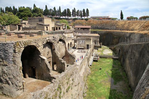
Herculaneum was a Roman city of perhaps 4K, maybe 5K, people when Vesuvius erupted in AD 79. Residents had mostly fled the community by the time deadly hot gasses killed over 300 remaining, many on the beach. (More may still be entombed in the volcanic deposits that remain unexcavated.)
The beach area is now covered in green vegetation along the right side of the picture. The grey wall bordering it and in the background are the volcanic…stuff (technical term) that buried the city, and remain along the margins of the excavated area and beneath the modern city. The volcano’s output pushed the shoreline back, and it is now over 1500 ft to the SE. The old beach, now exposed, is essentially a moat and would flood if pumps were not removing water at a huge rate. Anyway, the mini-forum where you see teensy people in the middle is the second story above the arched rooms that shippers would have used. The large arched rooms in the foreground are perhaps a third story (all high stories) above the ancient waterline. Residences sit even higher, and would have enjoyed fine ocean breezes. The upright evergreens along the far horizon line the main entry route (from the left), with views between oleanders into the ancient city.
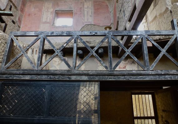
Perhaps the coolest thing about Herculaneum is that the volcano’s effects were different than at Pompeii, such that wood (and other organic materials) was carbonized in place and preserved. The balcony is from the first century AD, as is the screen below it. The red on the wall of the second floor is likewise ancient.
We underestimated how interesting we’d find Herculaneum.
Posted at 12:21 PM |
1 Comment »
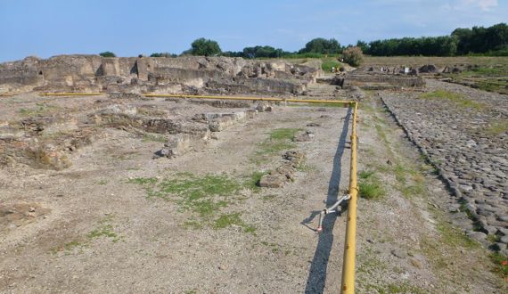
“There’s an archaeological site,” Someone Else said, “let’s stop.!”
And thus we had a wonderful guided tour of Sybaris—to the Greeks, or Copia—to the Romans. We saw the ruins of Copia, except for a stretch of the Greek’s road. (Read the Greek community’s history here.
You’re looking SSE toward the Roman center-of-town, which had a large circular city fountain, the theater, and at least one temple.
Apparently the coast side of Copia had a harbor and city gate, but the sea is now several hundred meters away. I guess sediment from the mountains washed down over the ruins protecting wall bases and floors, as well as the roads.
I’m not sure of the hydrology, but we saw and heard two busy pumps, keeping the water at bay. One place we could see the current water level, nearly 2m below the road—so the pumps must run continuously to keep the site from flooding—at least during rainy periods—and we experienced that recently. The yellow pipe is part of the water-removal system.
Thus, we have left Sicily, and are doing a quick perusal of the Ionian coast (Jonian is the spelling here). The B&B we stayed at hooked us up with a local Calabrian restaurant, and we dined with two French couples staying at the same B&B—a linguistic olympics for all of us, as we switched among French, English, and Italian, especially to discuss the foods we were eating. John used Google translate several times; for example, you gotta really know a language to know “white mulberry*” (Morus alba) in it—they were raw, fresh, sweet, and part of the fruit course along with dark, sweet cherries. Yum.
The white mulberries are probably a legacy of the silk industry. A town up the way, Catanzaro, was known historically for its velvet, silk and other textiles; I’m guessing that’s the link to the Morus alba trees….
* mûre
Posted at 10:22 PM |
Comments Off on Our sybaritic day
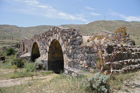
Near the northwestern edge of Mount Etna’s flows you can find the gorges of the Simeto (shallow compared to those in southeastern Sicily, like Pantelleria and Fiume Cassibile), with the four-arched (now) Saracen bridge crossing the flow (at 37.70094,14.79976; you can see the span in satellite view) northwest of Adrano.
I’m not sure how much of what we saw is ancient, or if mostly it’s just the stones—some of them—that are ancient, but the bridge is fascinating, with its undulating deck and multi-colored stones. I found the alternating light/dark of the facing stones of the arches mesmerizing.
From there, we went north-ish to Randazzo, then crossed the mountains to the north, sneaking peeks at Mount Etna in the rearview mirror. The pass where we left it behind was a gap, and unremarkable. On the north slope, we found trees, especially pines, whereas the south slope was mostly denuded (or with no trees)—as you can see in the bridge photo. Not sure how factors like prevailing weather patterns, soils, etc. play into this.
Posted at 2:48 PM |
Comments Off on The Simeto’s old bridge
Always, the tricky thing about archaeological finds is “saving” them. Stabilizing whole residential complexes of wall bases and Roman mosaic floors here at the Villa Romana del Casale is a major engineering project. I’m still amazed that conservators let you walk on some of the floors—on mosaic fragments. However, huge protective roofs and elevated walkways for the tourists are transforming this hillside into what looks like a series of greenhouses from afar. The corollary is that often shadows make study of the figures and designs in the mosaics, umm, difficult. And superheated.
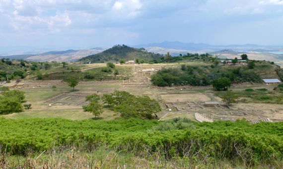
The lower zone of Morgantina includes the agora, stoa, granaries, and stores—a wide variety of special-use architecture, while the long-ago Greeks (well, their slaves) built residential architecture on the distant hilltop and the one I’m standing on, overlooking the core area of the settlement. The size of the bouleterion, or steps where citizens sat when they met to deliberate about community business, indicates Morgantina had a substantial population—and this was the mid-400s BC. And, yes, that’s a theater just peeking out from the vegetation in the right foreground.
Note how from this city, the residents could monitor activity over a wide area below. Note that their gleaming buildings could likewise be seen from a huge surrounding area.
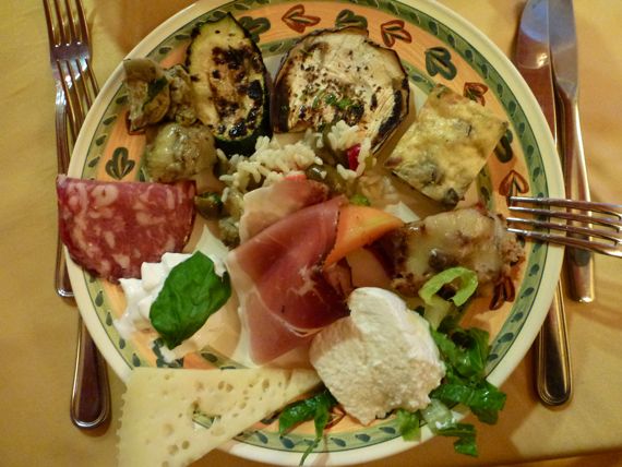
Here’s a sample of the good eats we’ve been enjoying—the antipasti we had tonight—two meats, three cheeses, an egg omelette(?), a cold rice salad, three veg, and a breadcrumb-stuffed red pepper. The meatloaf that arrived several courses later was tender and outstanding, with just a tiny bit of finocchio selvatico (wild fennel) as part of the flavoring, I was told. I guessed mint, but that’s probably because I know the Italian for it (menta), and I thought the flavor similar.
My vocabulary widens—slowly.
I am full. And that is all. (Hat’s off to KW for this style of sign-off.)
Posted at 3:53 PM |
2 Comments »

View ENE from cliffs above Castellammare del Golfo (Yes, the water is really that color). See the terrain in Google Maps by clicking here. Note that there’s a fortress-castle on the point that closes in CdelG’s harbor.
I did not understand how rugged the coasts of Sicily are. This is the NW corner of the island, looking back to the east. On the headland in the distance (left rear) is Palermo’s airport.
Notable facts from today, in no particular order:
- We are now a traveling duo, having said a heartfelt goodbye to our fine traveling companions at that same airport.
- We saw our first Prius in Italy, a shiny black one, arriving at the airport two cars ahead of us.
- Castellammare del Golfo was the port town for Segesta (37.94068,12.83426), which in ancient times controlled travel through the pass inland from Castellammare toward population centers in the SW part of the island.
- We did learn some lessons in the high art of snacking from F, although we did very well on our own today scoring a black-olive laced baguette to go with tiny mozzarelle spheres from the SISA up the road.
- Up by San Vito lo Capo we saw an abandoned tuna factory, including a net management area and housing for the fisher-dudes. The owners closed it in the late 1960s.
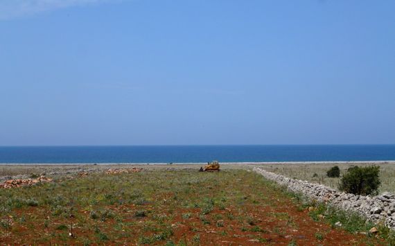
- We saw evidence of recent land speculation near San Vito lo Capo, across a bleak ocean-view terrain, partly cleared of its rocks (that’s a bulldozer out there), with boundary walls marking lots. Normally, we have seen unfinished or only partly occupied apartment buildings as evidence of the same over-development. For over a kilometer here, all we saw were stone walls, no houses, no gates, even.
- We begin our migration east and north tomorrow.
* “Blu” is Italian for blue.
Posted at 12:19 PM |
1 Comment »
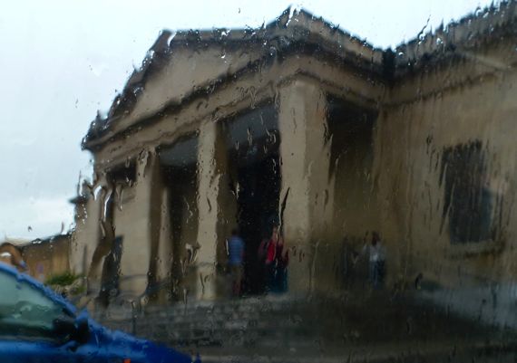
We got caught by the spring weather today.
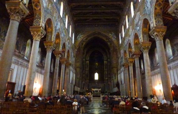
And, we caught mass at the famous duomo (cathedral) at Monreale, outside of Palermo. The roof is so far above, it’s hard to fathom. Plus, the glow of the gold when they brought the lights up for mass almost took my breath away. Probably no one, perhaps intentionally, recorded how many laborers worked to build this building, begun in 1174. The local masses made a poor showing at today’s noon mass, and the priest criticized us tourists for showing up. We got that much from the Italian.
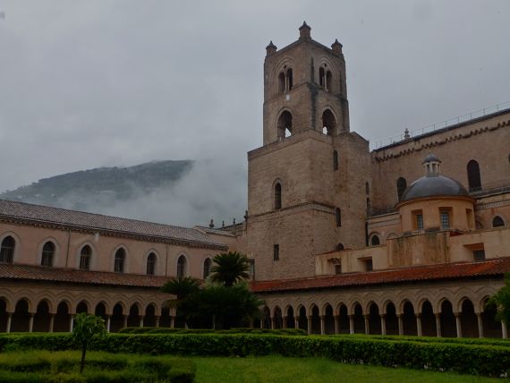
Still, we did cough up 6 euros each to visit the cloister, which meant we got to walk all four sides of the huge courtyard. Very scenic, surely, but I also got a bit queasy thinking about the lives lost so this could be built and decorated. I didn’t have time to study the Byzantine mosaics, just caught their gleam, mostly.
So, we stopped at the first picture last (yes, they’re not in chronological order). I hesitate to mention that we descended through a side door to look at catacombs (called a necropolis here if it is Greek, Roman, or early Christian, but apparently not if it is more recent) with embalmed or otherwise preserved corpses of Capuchin monks and community notables dating to the 1800s (older ones were not on view). Exceedingly strange. Prominent signs read No Fotos and No Film, as well as Show Respect (approximately). One said No Flash; I guess they were relenting a bit. Strange, considering high windows were open to the rainy outdoors, although the rain didn’t come in, just the terrifically humid air.
Milling around before we left, we saw a bier being loaded into a van through a door next to the entry. I saw the shoes through the glass, so I know someone’s remains were, shall we say, going on tour.
The rain’s back, we have a good internet connection, and we’ve talked to some home-folks, and that’s all for now.
Posted at 1:07 PM |
Comments Off on Chased by rain, we experience…strangeness
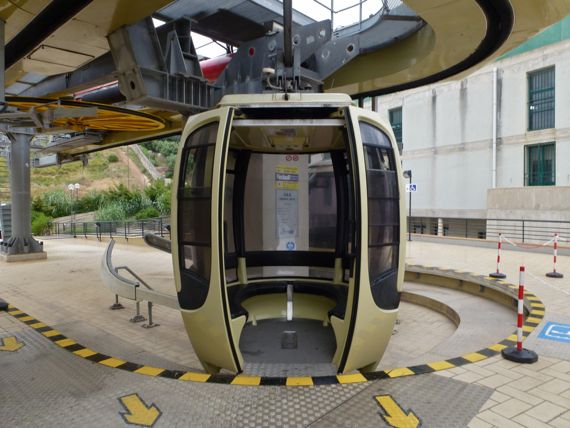
We avoided switchbacks, and their alter egos—tunnels, and took the funavia to historic hilltop Érice, which the Greeks called Eryx.
We saw churches (there are, I read, sixty of them), castles (or at least crenellations), lots of alley-streets, a few dogs and cats, some tourists (but it could have been worse), balconies, gated courtyards, and a few piazzas and salitas (“little rooms,” or openings smaller than a piazza).
When a cloud settled atop the city, we ducked into a Caffé for coffee and a sandwich, emerging when we felt the temps warm a bit.
One souvenir store we ducked into had a small shelf of Kodak 35mm print film above the cash register; I wondered what the expiration dates were on the boxes.
Posted at 10:22 PM |
Comments Off on Seats eight