Severe art-deco
Saturday, 13 July 2013
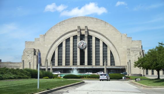
Sometimes Art Deco pieces look so cold to me. Like this sun-moment at the Cincinnati Union Terminal; even the sun couldn’t cut the formality and severity of the design.
To me, anyway….
Saturday, 13 July 2013
Sometimes Art Deco pieces look so cold to me. Like this sun-moment at the Cincinnati Union Terminal; even the sun couldn’t cut the formality and severity of the design.
To me, anyway….
Sunday, 23 June 2013
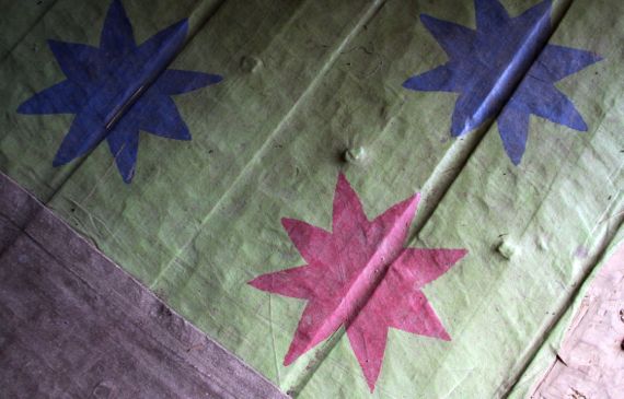
The image is oilcloth, or what passes for oilcloth. Funny stuff, oilcloth. The oil in oilcloth traditionally was linseed, that is oil from flax (Linum usitatissimum) seeds. Flax has a long history, and has been used for both fiber and seed-oil. Linseed oil has an usual property: over time, it sets up. So, for example, to make window glazing, it was mixed with chalk dust (hence the white glazing in old photos and paintings).
In “the old days,” oilcloth, although heavy and stiff, was a good choice for waterproofed applications. Waxed fabrics were another option. The later rubberized fabrics were a huge breakthrough.
No connection I can come up with between oilcloth and an unexpected thing I learned about today: the Vasari corridor. It’s a hobbit-trail/enclosed passageway dating to post-Medieval Florence…uhem…Firenze.
It connects the Palazzo Pitti with the Uffizi and Palazzo Vecchio. It crosses the Arno above the shops along the Ponte Vecchio, and passes through the upper reaches of a church, and above many homes. This is how the wealthy in pre-limo days commuted from home to office. In this case, the commuter was Grand Duke of Tuscany, Cosimo I de’ Medici (1519–1574). He lived on the south side of the Arno, in the gigantic Palazzo Pitti, and worked, or at least presided over, events in the Uffizi (offices), on the north side of the river. The corridor…just made his work-day easier.
The corridor was designed by Giorgio Vasari and built in five months in 1564. Today, access is nearly always closed, although along the walls of the almost 1 km long enclosed hallway are over 1000 paintings/works of art—the Uffizi’s self-portrait collection, which continues to receive new additions. There’s a second corridor off the north side of the Uffizi, with access to the Palazzo Vecchio. Thus, if you had the chops, you could move easily between the decision-making centers of Florence, and the stinky populace would have no idea you were strolling above.
The High Line is about a mile long, is in NYC, and the earliest section opened in 2009. It’s public, not private, and open to the skies, and thus quite different from the Medici pathway. They both have art, though.
Friday, 21 June 2013
Time is a difficult concept to grasp, frame, and master. But, as humans, we try mightily to do so.
The simplest time concept, I think, is the continuum—it’s all the same thing, going on and on.
Then you can get fancy, and introduce starting and ending points. Events, you might say.
Sometimes you can employ/deploy the idea of hinge points, or pivots, when something happens and things change going forward.
I keep thinking that overall it’s a matter of perspective, that reality is subjective, that we’re just fleas on Mother Earth’s back, belly, or neck.
Saturday, 15 June 2013
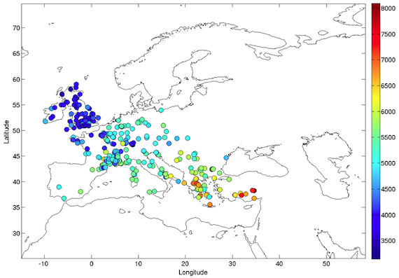
Improved version of Fig. 1 from Baggaley et al by Boy and Baggaley elsewhere on the interwebs.
Sooo cool. I’ve been thinking about making a version of this figure myself, just to see the pattern. Quite excited to find that someone else has already done so.
Shows a persistent impetus to move along. Note that as time goes along there are more dots for each color…which I interpret as more people, so more cultural deposits left to be dated….
Monday, 10 June 2013
Sometimes, this is what happens on a rainday—the sun comes out and mocks you as you do indoor work. Still, in this case, the indoor work was backlogged and now it isn’t.
To be fair, the rain didn’t totally stop until shortly after lunch.
Sunday, 9 June 2013

Bucrania—a new word for me I came across the other week…used in the context of the Neolithic Turkish settlement we call Çatalhöyük. The archaeologist I was reading defined it as cattle horns and skulls in a display context, interpreted as intended to impress, intimidate, and remind visitors how important their hosts were.
So, I drove up on this semi-load, and all these projecting arms were aligned and appeared as one, and thought: modern mechanical bucrania.
Tuesday, 4 June 2013

I understand these come in sets of four: 10YR, 5YR, not entirely certain of the other two. Handles, um, tend to fail.
Google your own set soon….
For extra credit: what color is your coffee?
For Munsell details, start with WikiPee.
Monday, 3 June 2013

From the other day….
The Guru says the Texaco font is wrong. I never wouldda figured that out…. My faves are the triangular stacks of oil cans in the windows.
Tuesday, 23 April 2013

I think this was just east of Amarillo.
I wonder if construction were beginning now if this architectural form would be used for local grain storage depots across the Great Plains.
Of all things! I just checked The Great WikiPee, and apparently the English word silo derives from the Greek word for a grain storage pit. Apparently, also, groups of silos and associated buildings, etc., are termed by their function: grain elevators. The architecture signals the shift from shipping grain in bags to in bulk, which changed dramatically in 1843, when the first mechanical complex was opened in Buffalo. Yes. Not on the Plains.
Friday, 12 April 2013
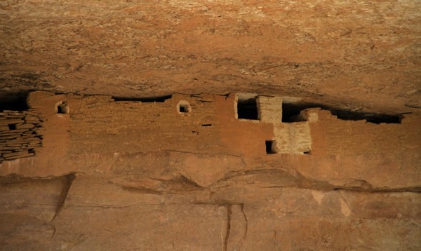
This storage area, just below the ceiling at Cliff Palace, could only be reached through houses in half of the architectural complex. Thus, the contents were controlled/secret. Why? Because it mattered so very much….
At Mesa Verde, the Ancestral/Ancient Puebloan* peoples abandoned their mesa-top and cliff dwellings in the late 1200s long before the Spanish arrived. They were small-statured people, in the 5-2 to 5-4 range. I’m figuring a big part of that was restricted calories. Sure, a pound of piñon nuts is something like 5K calories, but the rest of the dietary assortment is pretty low fat and the carb loads had to be, um, light, everything considered (like the calories it would take to navigate up and down cliff-faces…).
Speaking of food management, we enjoyed a lovely organic Nero d’Avila from Sicily that we found at the Log Cabin liquor store in Mancos—a pleasant surprise.
* More PC to use Ancestral/Ancient Puebloan rather than Anasazi….