Musings
The Indian name for this place, I swear, must have been something like “Rapids with herons and turtles downstream.”
Indeed, the post-Colonials who dammed this stretch must have been channeling (ahem) ancient times, when they named their flow-stopper Eagle & Phenix Dam (two majestic birds of reality and myth).
Of course, when they blew the dam, archaeologists…monitored…what was revealed….
And now, six months after the dynamite (or whatever they used), we saw many turtles, including one with a shell more than a foot long, and herons, including one that nabbed and swallowed a feesh right in front of us, just downstream of the old dam site (or dam old site).
Posted at 9:33 PM |
1 Comment »
Sometimes when you’re traveling (or amidst life), you have to let serendipity prevail. We made a side loop to visit…Cadillac. Because it was there.
And discovered it’s a walled town, with some plain but impressive ramparts (if, indeed, that’s what they are).
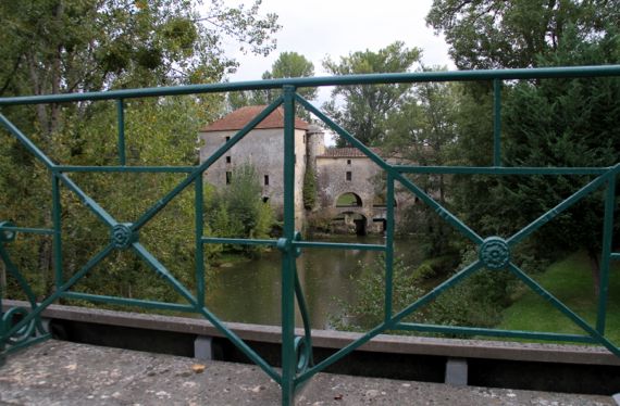
Then we took another side loop to check out a cultural feature signposted as “Pont Eiffel.” There was no pullout nearby, and no way to see the lacy metal support structure of the small (like three car-lengths) bridge in any detail, and we can only guess that the tour-Eiffel engineer had a hand in this one instead of merely influencing it. So, no bridge pix—only this one of the mill just upstream (no public access). Moral of this story: serendipity is sometimes just for your eyeballs—and imagination—and not for your camera.
Sometime later, we passed through an area where the grape-harvest was well underway. The trucks from the fields apparently back up to the gate appropriate to the variety they are carrying. The smell of souring grape-juice and the busy insects were the most dramatic impressions/activity at the moment we encountered this cooperative.
We covered some territory today, and the agricultural crops and general landscape went through several noticeable changes as we left the coast and moved through inland zones. We are overnighting in Perigord, and it is nut/fruit country—no grain and olives are long behind us, as are the chateaux of Bordeaux.
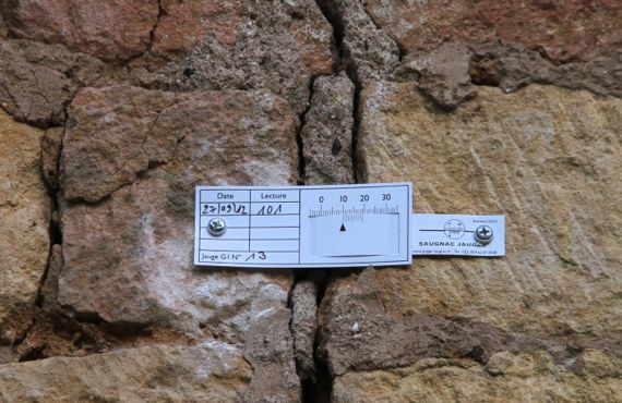
We’re staying in a really small town—the only biz is our B&B—with several homes and a church getting major attention from historic preservationists. The cracks in the walls are being monitored as restoration continues, using these simple calibrated slips.
Posted at 10:22 PM |
Comments Off on The changes we are seeing

Descending from the heights, like many people through history, our first stop was Saint-Jean-Pied-de-Port. Its medieval section is basically one main street, with perpendicular side streets (it’s not a hilltop town), adjacent to a river with a gorgeous little bridge. We saw school-bound kids crossing, stopping, as children will, to look in the water.
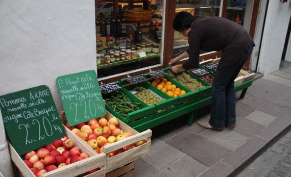
We were there early, and saw many shopkeepers opening for the day. You can tell that, although many shops catered to the tourists, people also live here—not many tourists buy apples by the kilo….
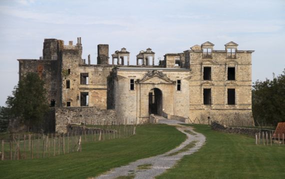
We detoured to Bidache to check out this ruined chateau. Without an appointment, we could only walk up to the front, but that by itself was pretty darned spectacular. We both found the tops of the stone window frames standing tall without their intended wall/roof partner-elements visually compelling.

How can this be last? Still, it was chronologically.
When we stood on the beach in the late afternoon, watching the surfing crowd trickle in (we theorized: after their day jobs), we knew we’d made tracks this day—from dawn in the Spanish Pyrenees to marine layer, late-day light on the Atlantic. What a great world.
Posted at 10:22 PM |
2 Comments »
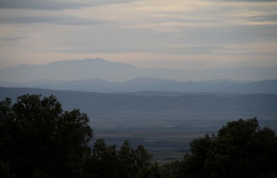
There’s a region near us, or where we’re staying now, called the Minervois, defined now as a wine region which historically was centered at Minerve. Many of the towns in this area have a version of Minerve in their names, a pattern I don’t remember from elsewhere in France. We looked in vain for a dolmen in the shrub-dominated garrigue on the ridge above town. Instead we discovered an incredible view, tinted in gorgeous shades of blue.
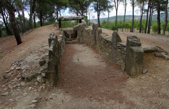
Several dolmen are known across the Minervois. This one is called Dolmen des Fades (or some variation thereof). Dolmen are, at least in the original definition, Neolithic-period megalithic tombs built across a broad swath of Europe. Seems to me that most of them are “empty” by now. We could tell there was quite a bit of reconstruction on this one, but the big stones did not appear to be from this hill. That’s a quick assessment, though.
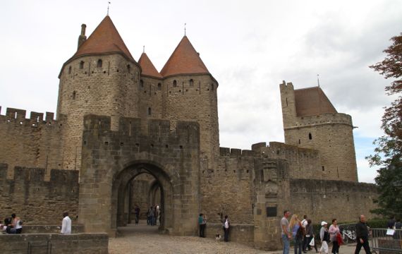
A bit later, we arrived at the east gate of the Cité, the fortified old town of Carcassonne (history in summary here and detailed here). The fortification has (at least) double walls, many towers and shooting positions, and encloses a separate fortified chateau (had a moat? now filled?)—look here (43.20731,2.36313).
I haven’t mentioned the Canal du Midi—we saw it yesterday (near Beziers first), and have been seeing it here and there as we cruise the countryside. Okay, here are the boaters at Homps, the “port” for Olonzac (our present home). The canal was built to facilitate a shipping route that avoided the Iberian coast, including the Barbary pirates.

I knew I could get us back to the political economy.
Posted at 12:26 PM |
Comments Off on Variability: Minervois, a megalith, a mega-fortification, canal
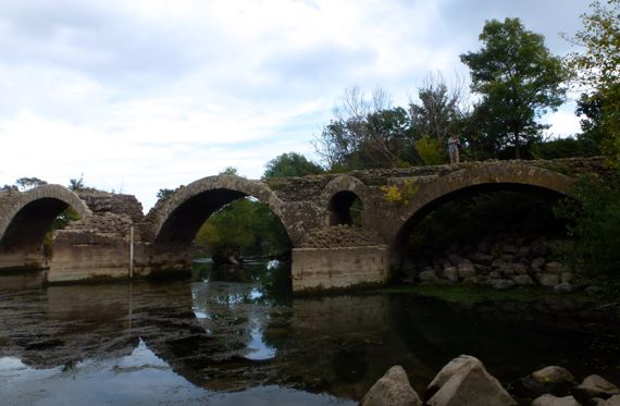
We revisited the Via Domitia. There’s a later mill immediately upstream from the remains of this structure. We saw pretty small fishies in the water, and slightly larger fishies keeping them company. Seems like there should have been even larger ones, but we didn’t see them.
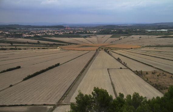
This is the strangest anti-irrigation engineering feat I can remember encountering anywhere. These radiating (actually pointing inward) canals brought water to the center of this circular area, sending the flow out through a drain, making a large marshy area useful for agriculture. This was done in the…13th C. I can’t tell who masterminded this project, or who funded it.
Posted at 12:22 PM |
Comments Off on Water problems solved
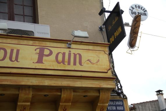
Reminder: pain in French means terrific bread; it is not painful to eat!
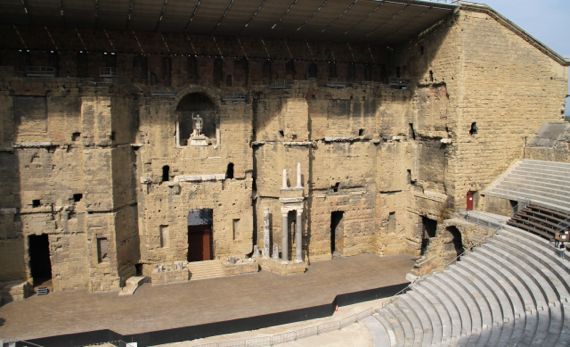
By the time this was built, estimated to be between AD 10 and 25, the Romans aimed to construct a complete architectural façade against which to stage their theatrical performances. As I understand it, the thrust of this was not only to be massive (see the tiny people to the far right of the frame) but to promote their vanquishing of this region. The formal name these days of this wonder is Théâtre antique d’Orange, and it is one of two that survive in this detail. Back in Roman days entrance was free; today you pay (that’s okay, your funds support maintenance), plus have to exit a winding trail through their junk shoppe.
Posted at 10:22 PM |
Comments Off on Of bread and…not quite circuses
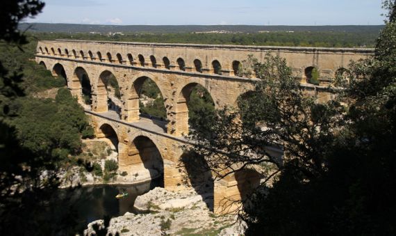
Stunning. This aqueduct, the Pont du Gard had a drop of 12.83 meters over the 50-km length of the run between the spring that fed it (we tried to get there and couldn’t—private property) and the catchment in Nîmes. The Romans of Nemausus wanted more water, and this is how they got it.
By observation, we would note that single kayaks, like this, carried quiet people, but if the kayaks passed by in clusters, yikes!—the noise.
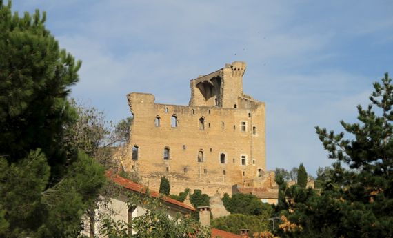
Châteauneuf-du-Pape is so named because the popes of Avignon came here back in the 1300s and developed grape-growing to have wine for their tables and to “share.” Now it is quite the wine center, with tasting places frequently encountered, both in town and along the feeder roads. The castle looming over town is a shell of its former self. The upper level has what look like machicolations that resemble those of the gothic Palais des Papes in Avignon.
Posted at 1:10 PM |
1 Comment »
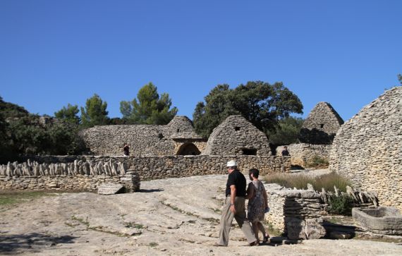
If you chose to live on a limestone deposit that will break into flat stones, you have the perfect material to make…corbeled-arch buildings. Around here, these are called bories, and the village of Gordes has several hundred to the west of downtown, a small cluster of which were restored in the early 1970s, and are now owned by the town. The earliest in this cluster date to the 1400s, but the oldest known date to well before Christ. I believe this cluster was abandoned early in the 20th C. Anyway, they’re quite…interesting.
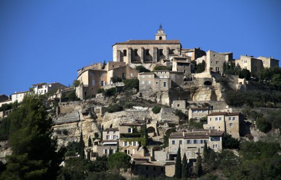
If you have a medieval mentality, you build on top of hills, and put your church on the highest ground. (Or maybe you command the populace to do so.) Terracing works to hold the slope yet make the steep terrain useful. Worldwide.

We wandered the small town square of Oppède-les-Poulivets (43.84360,5.16855), with about a dozen parked cars, and caught some nice late-afternoon light shots. Then a local bus arrived, and a bunch of kids got off, headed for the cars, and within three minutes, most of the cars had disappeared.
Posted at 10:22 PM |
1 Comment »
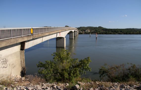
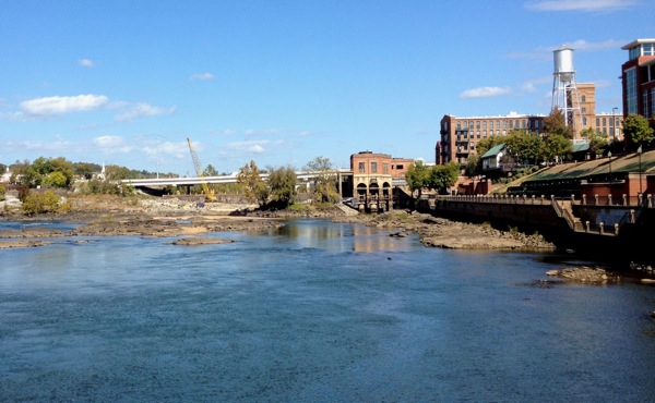
I keep thinking about the Rhône, and we keep visiting its environs, but I have yet to SHOW you the Rhône. So, here it is. A bridge downstream of Avignon—we were avoiding the afternoon traffic through town….
On our way back from…Ambrussum.
This is a Roman hillfort and surrounding community that basically was not trashed by later occupation. So rare.
Also, except for some foundation walls and part of the city-wall, there’s been no reconstruction here. I like that.
We had a hot walk (no rain today!) up the hill and on the trail, mostly looking at limestone chunks, with scattered sherdlets among the stone-crud. Parts of the trail followed the old Roman cobblestone ways.
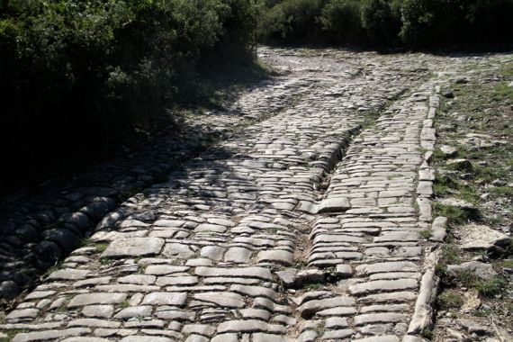
The interpretation is that these cart-wheel wear patterns date to Roman times. Given the layer of overburden and lack of medieval/later occupation here, I’d buy that.
This hillfort is immediately adjacent to the River Vidourle, although the fortified area is a slog above the river. Still, the community needed a bridge to be effective in controlling trade, and so it was.
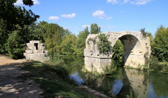
The bridge, Pont Ambroix, had a second standing arch maybe a century ago, the arch that connected to this bank. If you look into the water, you can see the large blocks that must have been part of the bridge, including on the other side of the standing arch. The vegetation growing among the stones doesn’t help preservation, either….
Ambrussum and other places we plan to visit as we proceed west are along the Via Domitia, the section of Roman road that went west from the Torino area (Po Valley, northern Italy), crossed the Alps, and dropped down to the upper Lower Rhône area, then went west paralleling the seacoast, and into the Pyrenees.
Title credit to The Guru.
Posted at 1:18 PM |
4 Comments »
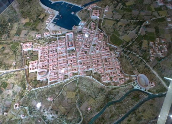
Diorama of Roman-period buildings in what is now Fréjus, known then as Forum Julii. Note the amphitheater (43.43438,6.72883), locally called the Arènes, and theater (43.43695,6.73811)—both survive. I’m standing on the “north” side, so you may consider this view “upside down.”
As is common in these parts, the medieval town of Fréjus is atop the Roman town. Here, though, archaeologists have had more of a chance than normal to delve into the Roman remains. Check out the boat basin (43.43122,6.74033), the economic hub of the community. It was silted in within centuries after the Romans faded from France, but, since it’s still low-lying, is now mostly open land, and almost perfectly bisected by a RR grade. A portion of a city gate/wall survives at the edge of it.
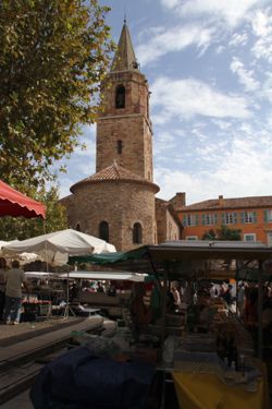
We enjoyed the hustle-bustle of market day, and I certainly wished I had a kitchen to retire to, and could justify buying the fine fish, cauliflower, fruits, and more that vendors offered in enticing displays on the west side of the church—but not in the plaza to the south (don’t know why).
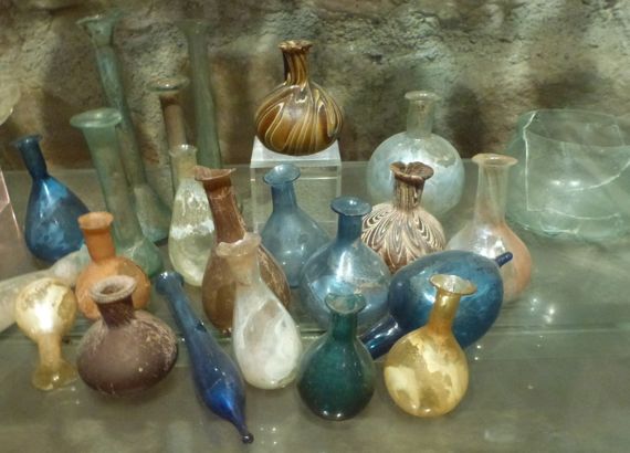
We very much enjoyed the small, high-quality archaeological museum, tucked around the north side of the church. These elegant perfume bottles testify to the fine-points of the Roman toilette, if you could afford such.
I consider Fréjus a lucky stop for us. We left our morning B&B in rain, drove in rain, but Fréjus was clear and even sunny. After we got back on the highway, we went through more rain. Lucky us, it was clear and sunny again by the time we got to our “new” B&B, where we’ll be for days. And nights.
We’re indulging here, and have paid for half-board, which means we go to dinner, four courses, just downstairs. Wine extra (duh!). Tonight: beef carpaccio with shaved parmesan, fresh basil and petit salade; fruits de mer (steamed or simply cooked fish, five kinds, one prawn) with lemon couscous served in a cream sauce that couldn’t be topped; fromage assortment; and sherbet trio (melon, red we couldn’t figure out, third I never figured out—all delicate and delicious) in a baked bowl made from two squares of filo, making a crunchy complement to the sherbet and two raspberries.
Posted at 10:22 PM |
2 Comments »