Musings
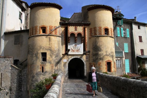
I am standing in the path of the Roman road that lead west from Rome skirting the coast of the Mediterranean. I think I read that this was the highest place along that route, which eventually went all the way to Spain. I am standing here (43.74522,7.40151), shooting south toward the gate that is some kind of post-medieval retread, and I suspect there was no gate here in Roman times. Anyway, just south of that gate is a 1930s reconstruction of a c. 6 BC piss-mark monument that has many names today. It celebrated the conquering by Augustus of many indigenous peoples living in the zone that today spans the French-Italian border in the southern Alps (a border which moved even in modern times). In case any subjects considered rebellion or otherwise forgot their place, this structure loomed above them at every turn, reminding them who the bosses were. The reconstruction dates to the 1930s. The original was robbed for building stones certainly during medieval times and probably before. The Roman stamp faded and the rebels could reassert themselves….
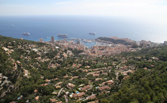
Standing here (43.74547,7.40345), on the end of a promenade the locals call the rondo, with carefully tended tiny plots of lawn and shrubbery and a rock noting that the Mayor of La Turbie made Prince Rainier an honorary citizen not too long ago, we looked down on the heart of Monaco.
Between us and the harbor, and just above the water, is the part of town where the famed casino is (we didn’t bet a penny, euro, or any other currency). That peninsula jutting out framing the other side of the harbor is the old part of town, Monaco-Ville, where the Prince’s Palace is (it’s the higher roof, of course). Since this is a politically independent place, I’d rather expect the top royal would be a king/queen, but, as you’re probably aware, that’s not the case. I’m sure the reason for this is noted somewhere, but I have either missed it or haven’t retained it.
After gazing out to sea for quite a while, and enjoying the breeze, we walked back to the car through the narrow winding streets, partly on the old Roman route, then drove down into Monaco, notching a third country on our belt for the trip so far (France, Switzerland, and…).
We, being mere colonials, had the idea that we could loop around Monaco-Ville, but a police-security guy was posted to deflect tourist cars from doing so. We opted not to walk there, either, and headed toward Nice on the basse corniche, the lower of the three along the stretch between Monaco and Nice.
In Nice, we skipped the Terra Amata site and museum (yes, very famous and Late Paleolithic, but), and did wander the Gallo-Romaine museum/ruins of Roman Cemenelum (more info here, on the dot-fr page; let Google translate help you), confusingly called Cimiez in all the off-site signage. The exposed zone has two bath complexes (different dates), sections of streets, and so on (check 43.71893,7.27610 in satellite view).
Fun day!
Posted at 3:02 PM |
1 Comment »
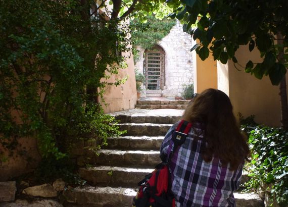
Carrying her loaded market bags, this local lady is headed…I dunno, to visit her sister? She’s crossing the bridge from the medieval section of Entrevaux to newer occupations across this defensible walkway. Note that right before the towers is a drawbridge (squint), of strong oak planks. I don’t know how often it is raised these days….
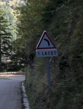
In these parts, a lacet is a shoelace. In this context, lacet means hairpin turns. I traveled (with the Guru driving) along more lacets today than any other day in my life. Please note that although we saw the highest road in Europe, we didn’t embark upon it (let alone traverse it). The roads we did traverse were plenty high and serpentine. Grazed the treeline, saw evidence of storms that came through about two days ago, but no trees across our path (whew!).
Thanks, readers! I’m heartened that you request MORE photos. The last B&B we stayed at had…limited internet service, so what I did post was a stretch. Today, well, I’m just plain tired. The upshot is, teeeheee, I get to show you more photos when I see you next!
Posted at 4:21 PM |
3 Comments »
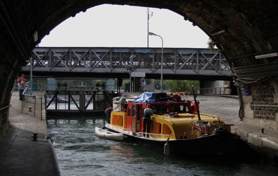
Canal beneath Pont Morland (48.84694,2.36578); every person on this boat (that we saw) was a women, and every one seemed to be a heavy smoker.
Following the Seine upstream for a bit, we discovered a canal! With a lock! And a boat going up into…the Bassin de l’Arsenal, where pleasure boats (that are not very tall) moor. It is the modified waterway that used to bring Seine water to the moat around the Bastille.
Posted at 1:57 PM |
Comments Off on Port de Plaisance
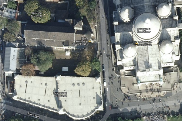
After our first visit to Montmartre, this is the church we look for to actually enter, the Église Saint-Pierre de Montmartre, the little church.
Okay, since you probably associate Montmartre with a different Catholic architectural wonder, here’s the big place (the basilica).

The other large building up here is ignored by most, skirted, and otherwise overlooked. Of course, it’s designed to disappear into the landscape, which is quite a feat considering its bulk and proximity to the two churches. It is the Réservoir du Montmartre—yes, a hilltop water storage facility.
If you’re wondering, we came up streets and steps from the northeast, and came down the “front.” Didn’t see Amélie.
Posted at 12:14 PM |
Comments Off on Hillcrest buildings
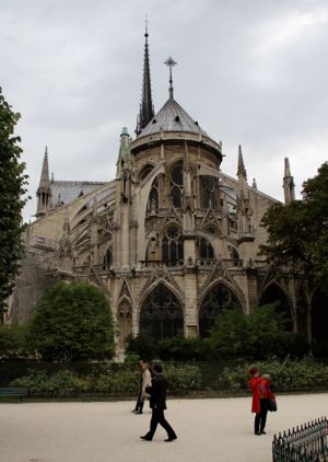
We began the day (a bit late; time change, you know) with gorgeous sunshine, but by the time we’d strolled to Île de la Cité, clouds had rolled in, and were transitioning from white to grey. So, here, around the backside of the Cathédrale Notre-Dame de Paris (so fancy architecturally—not from pure decoration like the door-façade—that it seems like this is the end that might make you want to become Catholic*), you can tell we’re probably about to get a message from gawd. Or something. (Meteorologists call it a on-again-off-again light rain, trying to become full-on light rain. Légère pluie here.)
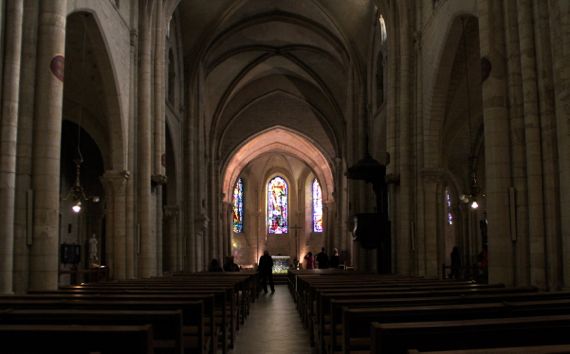
Still, we persisted with our footwork, crossing the bridge to the other island, Île Saint-Louis. Here, the légère pluie lost its intermittent quality. We did manage to find the restaurant we’d lunched at aeons ago, and the “little” church I remembered (crane your neck; the streets are narrow, and the roofline is high).
Undaunted by the pluie, we turned southish, detouring through part of the Jardin du Luxembourg. We traipsed around the back of the Sénat (or maybe the front; qui sait?), where I lost count of the number of guards we saw (distracted perhaps by the flowers and their plexiglass guard-stations, with all their electronic communication gear quite visible).
We had quite a trek, in short. Then, The Guru got the SIM to start working, but it may be out of data-money—there’s always something.
* Consider that the exterior long was painted quite colorfully, which would have made this view POP. Note, too, that the building is owned by France (or is it the city?, at any rate, not the Catholic Church), although managed by the clergy.
Posted at 1:00 PM |
1 Comment »
Snail Shell Harbor, Fayette—such a poetic name!
In the absence of pressing chores, we headed off to boost the haul of the state park system with our admission fee—and visited Fayette and Kitch-iti-kipi (the Big Spring). We prefer to stroll the streets of this ghost town in bright sunshine—and today we were certainly sun-warmed!
Posted at 10:22 PM |
Comments Off on Hot history

The fire-folk are fundraising—to stabilize and upgrade Atlanta’s oldest firehouse. Old buildings are expensive to keep. In this case, I understand the urge to keep rather than replace. This one suits the neighborhood, with all its architectural detail and rich-colored brick. Time to buy a t-shirt!
Posted at 10:22 PM |
Comments Off on Fire station 19
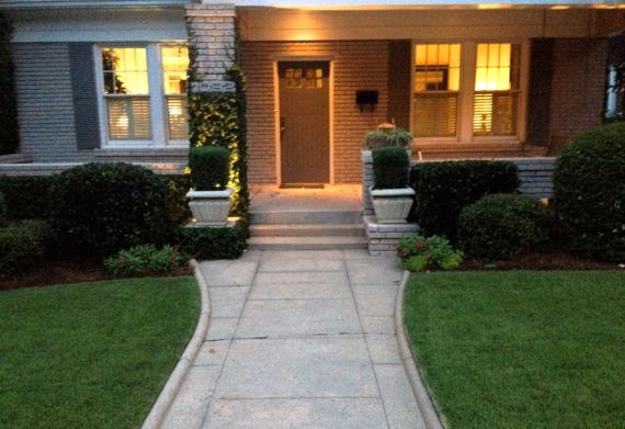
Weather and remodeling over the decades mean that most of these concrete walks that were original to the Va-Hi bungalows in this neighborhood—including in front of our home—are now gone. I have walked past this house dozens of times, and this is the first time I have noticed that its walkway survives. I’ve always enjoyed the delicate rolled molded margins that no doubt stymie lawn upkeep.
Posted at 10:16 AM |
Comments Off on Detail underfoot
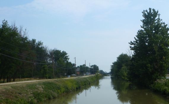
That is: Spencerville Oh-Aich.
This canal, the Miami and Erie, was Spencerville’s economic lever for several decades. Today, sections of the canal sport duckweed and make “lazy river” sound like whitewater. This section has a bit more energy, but no more cargo.
Today, Spencerville was cranking up for a weekend of fried food and carnival rides, which took over the main street, but lacked attendants and patrons when we passed through before lunch-time.
We followed the canal for quite a ways, and even saw one spot where it flowed above a natural river—rather strange.
Economics two days in a row? Apologies!
Posted at 7:09 PM |
Comments Off on Economics of Spencerville

View to southwest.
Hey, I’ve been escaping reality by spending time with Google Earth. Check out the 3-D version of the two-tiered Pont du Garde Roman aqueduct, northeast of Nîmes.
Posted at 12:23 PM |
Comments Off on Flying (sorta)